River Yare & Claxton from Rockland Staithe Walk
Walk 3348 - Route Maps
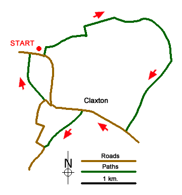
Route Map
Digital Maps - Copyright © 2011-2024. All rights reserved.
Sketch Map
Suggested Maps 

| Ordnance Survey Explorer OL40 | Sheet Map | 1:25k | BUY |
| Anquet OS Explorer OL40 | Digital Map | 1:25k | BUY |
It is recommended you take a map. The preferred scale is 1:25k.
Start Point Details
Ordnance Survey Grid Ref TG327046
Latitude 52.589355 Longitude 1.433925
Postcode NR14 7HP
what3words start minivans.defends.objecting
Walk description may contain detailed information on the start point for this walk.
Further Information
The Broads
Walking in the Norfolk and Suffolk Broads offers a unique mosaic of rivers and shallow lakes, marshes, fens and woodland. This unique habitat is home to some of the rarest plants and creatures in the UK. The Broads is also one of Europe's most popular inland waterways. Once an essential transport network the waterways have evolved for recreational use. Besides the blend of wildlife and distinctive landscapes, man has made his mark with distinctive buildings including some fine windmills. The Broads Walking Guide
Norfolk
The county of Norfolk lies in Eastern England. Its northern and eastern boundaries are the North Sea and to the northwest, The Wash. Norfolk is a largely rural county and well-known for its network of rivers and lakes known as the Broads. This area is not a national park although it has a similar status to a national park. Norfolk's low-lying land and easily eroded cliffs, many of which are composed of chalk and clay, make it vulnerable to weathering by the sea with the coast between Kelling and Lowestoft Ness in Suffolk the most at risk. Norfolk is a popular tourist area with several major attractions. There are many seaside resorts, with some having Britain's finest beaches including those at Great Yarmouth, Cromer and Holkham. In addition to protected area of the Broads, there is also the Norfolk Coast National Landscape (formerly AONB). Many areas of the coast are wild bird reserves. Tow national trails, The Norfolk Coast Path and The Peddar's Way.
Walk grading - Learn how each walk is assessed and select a walk to suit your ability and experience by going to Walk Grading Details.
Messaging & Social Media
Message Walking Britain and follow the latest news.

Mountain Weather
Stay safe on the mountains with detailed weather forecasts - for iOS devices or for Android devices.