Walk 3354 - printer friendly version
Glen Banvie and Blair Castle from the Falls of Bruar Walk
Author - Lou Johnson
Length - 11.3 miles / 18.4 km
Ascent - 1400 feet / 424 metres
Grade - moderate
Start - OS grid reference NN820660
Lat 56.7705890 + Long -3.9322963
Postcode PH18 5TW (approx. location only)
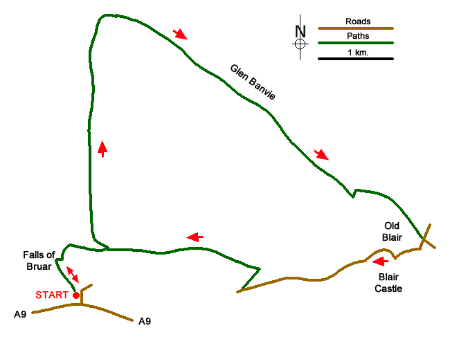
This walk covers a variety of scenic interest from forests, a lonely glen and the grounds of Blair Castle. The route does need careful navigation and the appropriate OS Explorer maps are useful in following the route. The start is the car park at the House of Bruar (grid ref. NN820660 on the north side of the A9 some three miles west of Blair Atholl.
After parking follow the signed Falls of Bruar walk. The route initially follows the river's west bank but soon crosses to the other side (grid ref. NN818663) where you continue upstream for about 300 metres where you leave the riverside path to join a track heading east (grid ref. NN820666). Stay on this track for approximately 600m metres to reach a T- junction (grid ref. NN825665). Turn left and continue through the forest for a further 600 metres to take the left fork with a red arrow (grid ref. NN823670).
The navigational difficulties are mostly overcome and you head north along the track through Glen Banvie Wood to reach open country and a junction (grid ref. NN826696). Ignore the path heading north to Ruichlachrie and bear east into Glen Banvie, remaining on the main track. A gentle descent with Banvie Burn on your right provides easy walking and it is likely you will be able to enjoy the solitude of the Glen. The track enters Whim Plantation and after 700 metres you take the bridge across Banvie Burn (grid ref. NN858672). Bear right after crossing the Burn and in 400 metres take the right fork (grid ref. NN862673) and continue down to a junction at Old Blair (grid ref. NN867666).
Turn right and continue to Castle Avenue (grid ref. NN864664). Turn right and follow the road for over a mile to reach a 5-way junction (grid ref. NN843660). Turn sharp right here and continue uphill for 400 metres or so where you follow the track as it bends to the left at a junction (grid ref. NN845662). Keep on this track for over a mile to reach the point where you joined this track at the beginning of the walk (grid ref. NN820666). All that remains is to turn left down the path and retrace your steps back to the car park.
Messaging & Social Media
Message Walking Britain and follow the latest news.

Mountain Weather
Stay safe on the mountains with detailed weather forecasts - for iOS devices or for Android devices.