Walk 3359 - printer friendly version
Christmas Common, Ibstone Common & Turville Heath Walk
Author - Lou Johnson
Length - 8.5 miles / 13.8 km
Ascent - 1100 feet / 333 metres
Grade - easy/mod
Start - OS grid reference SU715931
Lat 51.6321770 + Long -0.9683532
Postcode OX49 5HN (approx. location only)
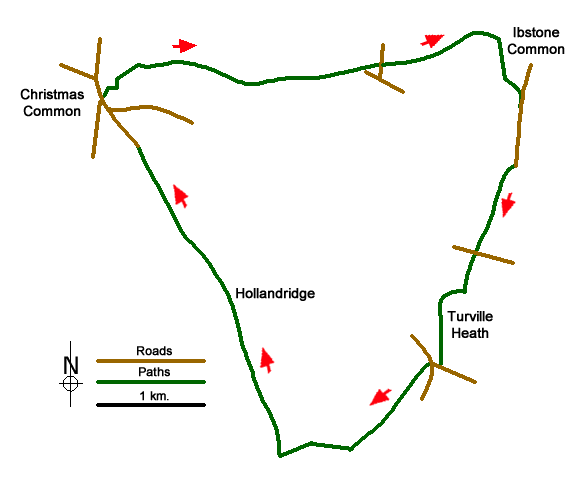
The Chilterns feature a variety of landscapes including woodland, dry valleys, rounded hills and common lands. This Buckinghamshire walk includes all of these and offers an interesting insight into this Area of Outstanding Natural Beauty. The start is roadside parking at the northern end of Hollandridge Lane at Christmas Common (grid ref. SU715931). Alternative parking is available at the parking area on the western slopes of Watlington Hill just to the west of the centre of Christmas Common on Hill Road at grid ref. SU710935.
After parking on Hollandridge Lane walk north towards the main road junction in the centre of the village (grid ref. SU714932) and take the signed footpath on your right. Follow this path as it turns right and then left to enter woodland and meet a track (grid ref. SU716934). Turn right following the signs for PY3 and follow the path into woodland. Previous walkers have made a short cut which bears right off the official right of way to meet a cross path on the southern edge of Shotridge Wood (grid ref. SU718935). Turn right and almost immediately bear left onto a descending path (signed SH4) through Shotridge Wood. Follow this path for just over a mile through woods to reach a junction with the Chiltern Way (grid ref. SU735934), where you keep straight ahead to reach a driveway.
Stay on the Chiltern Way leaving this driveway on your left and continue across fields and climb up into Commonhill Wood. The path climbs along a track/path in a gulley to reach the western boundary of Ibstone Common. The onward route turns right and follows the boundary of the common south. (Note if you require refreshments you can cross the common to the Fox Hotel). The route is well waymarked and leads you onto a lane (grid ref. SU751932). Walk south passing Hellcorner Farm and continue in a southerly direction. The route follows this quiet tarmac lane for about 400 metres until it becomes a rougher track. In a further 600 metres you reach a footpath sign on your right. Take this path and descend into an open valley. Go through the narrow strip of woodland, cross an access driveway and continue in the same direction to reach Holloway Lane (grid ref. SU747919).
Cross the lane and take the signed bridleway opposite and follow this up to Turville Heath. A further refreshment opportunity lies to your left at the Barn Café. To continue the walk head almost due south across Turville Heath to reach a road (grid ref. SU744909). Turn right along the road to a junction with a bus shelter on your right (grid ref. SU743909). Cross the road and take the signed footpath which is hidden in a corner between houses. This leads across fields to join a track (grid ref. SU740905). Keep straight ahead along the track which soon descends into a valley with a wonderful view to Stonor on your left.
Cross the bridleway at the bottom of the hill and climb gently alongside a recently planted row of Lime Trees to reach Hollandridge Lane (grid ref. SU730901). Turn right and follow this almost traffic free byway for just over two miles back to Christmas Common.
Messaging & Social Media
Message Walking Britain and follow the latest news.

Mountain Weather
Stay safe on the mountains with detailed weather forecasts - for iOS devices or for Android devices.