Mynydd Mawr & Porth Meudwy Circular from Aberdaron
Llyn Peninsula Walk
Region - Llyn Peninsula
County/Area - Gwynedd - Llyn Peninsula
Author - Lou Johnson
Length - 7.0 miles / 11.4 km Ascent - 1100 feet / 333 metres
Time - 4 hours 40 minutes Grade - moderate
Maps 

| Ordnance Survey Explorer 253 | Sheet Map | 1:25k | BUY |
| Anquet OS Explorer 253 | Digital Map | 1:25k | BUY |
Walk Route Description
Click image to see photo description.
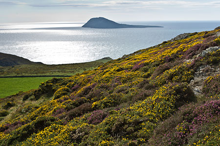
This walk from Aberdaron explores the most westerly headland of the Llŷn Peninsula. The route follows the Wales Coast Path to Porth Meudwy before crossing the headland to enjoy views to Bardsey Island. The walk then returns to Aberdaron along the coast path with fine views along this beautiful coastline.
The start is the main car park in Aberdaron (grid ref. SH172264). After parking, exit the car park and turn left up the road signed to Whistling Sands. Follow the road to reach a small parking area. From here bear left through the metal gate by the roadside to join the Wales Coast Path. The path then follows the cliff top with a fine view back to Aberdaron. The path soon descends down steps to cross a footbridge before climbing steps to reach a kissing gate. Continue climbing to regain the clifftop. A section of easy walking with good views across Aberdaron Bay leads through several gates and down steps to the secluded cove of Porth Meudwy.
The route now turns inland. From the cove, turn right up a track. After 350 metres, just before the track swings right, turn left on a narrow footpath, cross a footbridge and climb steeply up to a farm and adjacent campsite. Go through the campsite to reach a lane (grid ref. SH157257). Turn right along the lane and after 100 metres take the signed footpath through a metal kissing gate on the left. Follow the path to another lane. Turn right and after a short distance turn left down the access track to a cottage. Just before the cottage go left through a kissing gate and along an enclosed path to a stile. Head straight across several fields to a farm. Pass through the gate beside the farm and follow a track to reach a lane (grid ref. SH150258).
Turn left along the lane and continue ahead for 800 metres. Cross a cattle grid to enter the National Trust land at Braich-y-Pwll. Almost immediately, bear left off the lane onto a grassy path with a wall on your left. At the end of the wall continue straight ahead and descend alongside a stream to meet the Wales Coast Path (grid ref. SH141253). Turn left and follow the waymarked path across the rocky flank of Mynydd y Gwyddel. Ahead you can see Bardsey Island which lies a few miles offshore. The path briefly turns inland across a promontory to rejoin the coast at Porth Felen.
After passing the small island of Carreg Du, the path swings left and climbs more steeply with the cliffs around the inlet of Parwyd to your right. Pass through a metal kissing gate and continue the climb to another kissing gate. Note the route of the Coast Path has been revised on this section and differs to that shown on some older OS Maps. After another kissing gate the path leads down to the headland of Pen y Cil. The path swings left and ahead you have a view along the coast to Aberdaron.
You now have about two kilometres of pleasant coastal walking along a well waymarked path to reach Porth Meudwy down a flight of steps. Continue up the other side and retrace your steps back to Aberdaron. As an alternative, and if the tide permits, you can walk along the beach. As you descend to the footbridge take the rusty kissing gate on the gate and descend steps down to the beach. Turn left along the beach back to the start.
Other walks nearby
| Walk 3339 | Mynydd Anelog & the Whistling Sands | easy | 4.5 miles |
| Walk 3377 | Pen y Cil & Porth Meudwy from Mynydd Mawr | moderate | 5.7 miles |
| Walk 3375 | Mynydd Penarfynydd from Rhiw | easy | 3.3 miles |
| Walk 3371 | Mynydd Cilan from Hell's Mouth | moderate | 7.3 miles |
| Walk 3381 | Carn Fadryn Hillfort | easy | 1.5 miles |
| Walk 1796 | Garn Bach & Carn Fadryn | easy/mod | 5.0 miles |
| Walk 3382 | Llanbedrog Headland Circular | easy | 2.5 miles |
| Walk 3376 | Porth Dinllaen from Morfa Nefyn | easy | 4.5 miles |
| Walk 1762 | Pwllheli, Llanbedrog & Abersoch | easy/mod | 9.0 miles |
| Walk 3044 | The Rivals (Yr Eifl) from Llithfaen | moderate | 4.5 miles |
Recommended Books & eBooks
Snowdonia: 30 Low-level and easy walks - South
 Guidebook describing 30 walks in Snowdonia, Wales. Routes are mostly low level and on clear paths and showcase the region's beautiful scenery and rich history and culture. Part of a 2-volume set, this southern volume includes Trawsfynydd, Bala, Dolgellau, Machynlleth, the Harlech Coast and the valleys of the Mawddach and Dyfi.
More information
The Wales Coast Path
 A single guidebook to walking the whole Wales Coast Path - 1400km (870 miles) the length of Wales from Chester to Chepstow, including Anglesey, described in 57 stages. The route passes through the Snowdonia and Pembrokeshire National Parks and many AONBs and can be linked with the Offa's Dyke Path for a complete circuit of Wales.
More information
Messaging & Social Media
Message Walking Britain and follow the latest news.

Mountain Weather
Stay safe on the mountains with detailed weather forecasts - for iOS devices or for Android devices.