Walk 3384 - printer friendly version
Aysgarth Falls and Caperby Walk
Author - Lou Johnson
Length - 4.0 miles / 6.5 km
Ascent - 250 feet / 76 metres
Grade - easy
Start - OS grid reference SE011887
Lat 54.2939190 + Long -1.9846021
Postcode DL8 3TH (approx. location only)
This Yorkshire Dales walk in Wensleydale explores the three waterfalls on the River Ure at Aysgarth. The route is extended to cross pleasant farmland around the attractive village of Carperby with its stone cottages around the village green. The walk also offers wider views across Wensleydale to the hills in the south.
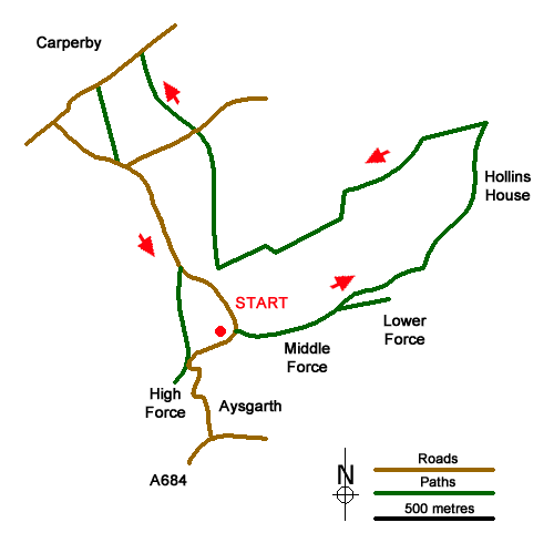
The start is the National Park Visitor Centre by Aysgarth Falls (grid ref. SE011887) where there is a pay and display car park, toilets, and information centre. After parking follow the path signed to the Lower and Middle Falls. Cross the road and go through a gate from where you take the right fork signed to the falls and Castle Bolton. After a short distance turn right down a path to the viewpoint at the Middle Falls. Return to the main path and turn right. Go through the kissing gate and continue past the return path for Lower Falls. Continue ahead down steps for Lower Falls and continue through gate and down more steps bearing right for Lower Falls viewing point. Continue to pass close to the river (on your left).
Follow sign for return path to re-join the outward route. Turn right and then fork left signed to Castle Bolton. Follow path through a gate and head to the right of the farm ahead. Continue through three gates to join a track. Pass through buildings and continue through a gate and bear left. Pass through another gate, bend left and then take the path on the right. Follow the fence on your right through a gate. After 150 metres go left signed to Freeholder Wood. Cross the field, go through a gate, and turn right along the track. Cross the old railway and turn left through a gate signed to Aysgarth.
The path continues beside a stand of trees on your left and continues in the same direction to pass a solitary tree in the next field. Aim for another solitary tree and bear left following the marker post and track. Continue to just before a bridge and turn right through gate. Follow the left-hand side of the field, go through enclosed area, go half right to cross stile by a tree. Continue into Freeholders Wood following path to a junction. Fork right and curve left through trees. Just before a marker, cross tile on the right. Follow the path across several fields to a lane (grid ref. SE011896).
Turn right along the lane and almost immediately left over a stile along a path signed to Carperby Village. The path follows the right-hand wall into a narrow field. Go through gap with a footpath sign and keep right in the next field. Pass through gate to head left up field across a bridge. Continue to exit onto the road at Carperby. Turn left through the village. After 150 metres take the track on the left signed Low End Lane. Follow the path over several fields to reach a lane.
Turn left and just after the lane bends right, take the signed footpath on the right. Once through the gate, turn left and keep the wall on your left. The path runs parallel to the lane on your left. At the second kissing gate you can either turn left back to the carpark or right to visit Upper Falls where a small fee is payable to reach the river. If you visit the Upper Falls retrace your steps back to the kissing gate and return to the car park.
Messaging & Social Media
Message Walking Britain and follow the latest news.

Mountain Weather
Stay safe on the mountains with detailed weather forecasts - for iOS devices or for Android devices.