Darnbrook Fell & Fountains Fell
Yorkshire Dales Walk
Nat Park - Yorkshire Dales - Three Peaks Country
County/Area - North Yorkshire
Author - Lou Johnson
Length - 6.4 miles / 10.4 km Ascent - 1100 feet / 333 metres
Time - 4 hours 20 minutes Grade - moderate
Maps 

| Ordnance Survey Explorer OL2 | Sheet Map | 1:25k | BUY |
| Anquet OS Explorer OL2 | Digital Map | 1:25k | BUY |
Walk Route Description
Click image to see photo description.
This Yorkshire dales walk visits Darnbrook Fell and Fountains Fell which lie to the east of Pen-y-ghent. Both fells see relatively few walkers and offer views to Pen-y-ghent and beyond. The route uses a short section of the Pennine Way although for part of the route paths are less distinct with a map and map reading skills useful assets.
The start is the grassy area on the minor road from Stainton to Halton Gill just north of Rainscar where the Pennine Way comes down from Fountains Fell (grid ref. SD853723). After parking follow the road north towards Halton Gill. After 600 metres fork right off the road following the path signed to New Bridge. Follow the clear track for just under three kilometres of easy walk as you enjoy the view with Pen-y-ghent rising to your left. Reaching a derelict barn and adjacent gate on your right (grid ref. SD885741), turn right through the gate and follow a feint path uphill with the wall to your left. Follow the wall until a wall comes in from the right (grid ref. SD881730).
Pass through one of the gaps in the wall on your right, and head south-east along the wall and along a fence to reach the OS trig point on Darnbrook Fell (grid ref. SD885728). The summit of the fell is a sea of peat although the views to Pen-y-ghent and Plover Hill and the twin peaks of Fountains Fell more than compensate for the drab surroundings.
To continue return along the fence to a gate and head south-west along a wall. On your left you can see Malham Tarn in the distance whilst to the west the view extends to Morecambe Bay! Continue for 1.5 kilometres to reach a ladder. Once across the stile, head south-west to cross the Pennine Way to reach the summit of Fountains Fell which is adorned with several tall cairns.
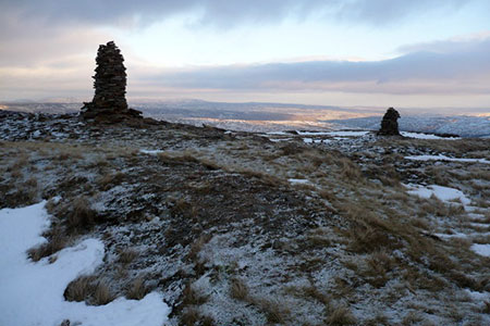
Take time to enjoy the view which now includes Ingleborough and on clear days some Lakeland Fells. Fountains Fell was once the site of coal mines and today shafts have been protected with fencing. After enjoying the view, return to Pennine Way and turn left following the well-trodden path back to the start.
Other walks nearby
| Walk 1121 | Pen-y-ghent & Plover Hill | moderate | 9.0 miles |
| Walk 1013 | Pen-y-ghent | moderate | 6.5 miles |
| Walk 1500 | Pen-y-ghent via Horton Scar | moderate | 6.8 miles |
| Walk 3433 | Yorkshire Three Peaks from Horton-in-Ribblesdale | very hard | 24.5 miles |
| Walk 1278 | Cosh & Foxup | easy/mod | 6.5 miles |
| Walk 1926 | Pen-y-ghent & Littondale | hard | 16.0 miles |
| Walk 2649 | Attermire Scar & Malham Tarn from Stainforth | mod/hard | 16.5 miles |
| Walk 3092 | Malham Cove, Malham Tarn & Watlowes | easy | 4.4 miles |
| Walk 2617 | Nappa Cross & Victoria Cave from Langcliffe | moderate | 9.5 miles |
| Walk 1404 | Oxenber and Wharfe Woods from Langcliffe | moderate | 10.5 miles |
Recommended Books & eBooks
The Pennine Way
 Guidebook to the Pennine Way National Trail with OS map booklet. The 265 mile route from Edale to Kirk Yetholm takes three weeks to walk and is suitable for fit and experienced long distance walkers. The route crosses the Peak District, Yorkshire Dales and North Pennines National Parks. Includes separate OS 1:25,000 map booklet of the route.
More information
Pennine Way Map Booklet
 Map of the 270 miles (435km) Pennine Way National Trail, between Edale in the Peak District and Kirk Yetholm in the Scottish Borders. This booklet is included with the Cicerone guidebook to the trail, and shows the full route on Ordnance Survey 1:25,000 maps. This popular long-distance route typically takes three weeks to complete.
More information
Messaging & Social Media
Message Walking Britain and follow the latest news.

Mountain Weather
Stay safe on the mountains with detailed weather forecasts - for iOS devices or for Android devices.