The Wey & Arun Canal, Loxwood
West Sussex Walk
County/Area - West Sussex
Author - Lou Johnson
Length - 4.5 miles / 7.3 km Ascent - 80 feet / 24 metres
Time - 2 hours 20 minutes Grade - easy
Maps 

| Ordnance Survey Explorer OL34 | Sheet Map | 1:25k | BUY |
| Anquet OS Explorer OL34 | Digital Map | 1:25k | BUY |
| Ordnance Survey Landranger 187 | Sheet Map | 1:50k | BUY |
| Anquet OS Landranger 187 | Digital Map | 1:50k | BUY |
Walk Route Description
Click image to visit gallery of 9 images.
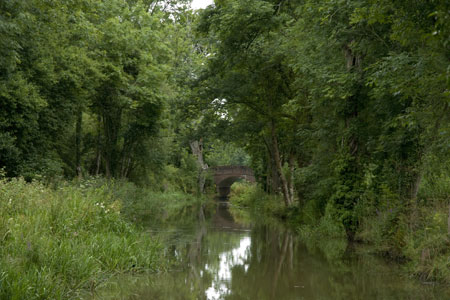
The Wey & Arun Canal runs through Surrey and West Sussex. In the 19th century boats could travel from London to Littlehampton via the rivers Wey and Arun, linked between Shalford in Surrey, and Pallingham in Sussex, by the 23-mile Wey and Arun Canal. The Wey and Arun Canal was the only canal between the south coast and the Thames. In 1871 the canal was abandoned and fell into disrepair. However a group of enthusiasts started restoration in 1970 and today the Wey & Arun Canal Trust are aiming to complete restoration of the canal back to a navigable state. By 2008 significant sections had been restored and with a number of large projects under way progress was evident.
This walk starts from Loxwood and follows the restored section of canal in an easterly direction using both rights of way and a concessionary path along the canal bank. Traffic on the canal is limited as the section is isolated from other completed parts of the restoration project. However a number of locks and overbridges have been reinstated giving the impression that the canal has never closed.
The start is the Onslow Arms (grid ref. TQ041311). If parking here do obtain permission prior to starting the walk. Walk east along the canal. You soon reach Brewhurst Lock and continue under Brewhurst Bridge. The route meanders through pleasant woodland to pass Baldwin's Knob Lock and Barnshill Bridge to reach the Drungewick Aqueduct and Drungewick Lane Bridge.
Leave the canalside path, cross Drungewick Lane Bridge and follow the path now on the north bank of the canal. This is not a public right of way although the landowner has granted permission for the public to use the path on a concessionary basis. Soon the canal reaches Drungewick Lock and Bridge after which it is only a short distance to the current end of navigable canal. Looking ahead down the unrestored section soon makes one appreciate the task in hand.
Having explored this section of the canal the easiest way back is to follow the outward route. However there are a number of footpaths in the area and these could be used to construct a circular walk. For more information on this project visit the Wey & Arun Canal Trust web site.
Other walks nearby
| Walk 1425 | Midhurst Way - Petworth to Midhurst | easy/mod | 5.5 miles |
| Walk 1869 | Thorncombe Street from Bramley | easy/mod | 6.0 miles |
| Walk 3228 | Black Down from Haslemere | easy/mod | 10.0 miles |
| Walk 1424 | Midhurst Way - Haslemere Stn to Midhurst Bus Stn | moderate | 9.5 miles |
| Walk 1514 | Gibbet Hill & the Devil's Punch Bowl from Haslemere | easy/mod | 7.0 miles |
| Walk 2102 | Leith Hill circular | easy | 1.5 miles |
| Walk 2232 | Midhurst and Woolbeding | easy/mod | 6.0 miles |
| Walk 2124 | Leith Hill and Box Hill, two of the Surrey Hills | moderate | 12.5 miles |
| Walk 1667 | Blackpatch Hill & Harrow Hill from near Storrington | easy/mod | 7.2 miles |
| Walk 3464 | Rackham Hill & Kithurst Hill Circular | easy/mod | 6.7 miles |
Recommended Books & eBooks
No suggestions for this area.Messaging & Social Media
Message Walking Britain and follow the latest news.

Mountain Weather
Stay safe on the mountains with detailed weather forecasts - for iOS devices or for Android devices.