Byrlip and Ceredigion Coast Path from New Quay
Ceredigion Walk
County/Area - Ceredigion
Author - Lou Johnson
Length - 5.7 miles / 9.3 km Ascent - 1000 feet / 303 metres
Time - 3 hours 50 minutes Grade - easy/mod
Maps 

| Ordnance Survey Explorer 145 | Sheet Map | 1:25k | BUY |
| Anquet OS Explorer 145 | Digital Map | 1:25k | BUY |
Walk Route Description
Click image to see photo description.
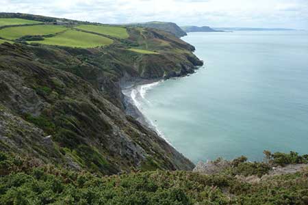
The Ceredigion Coastal Path opened in 2008 and is now an integral part of the Wales Coastal Path running the length of the Principality. This walk explores the section of coast lying to the south of New Quay. The outward route follows tracks and lanes lying inland from the coast with a return to the start following the Ceredigion Coastal Path. Like all coastal walking you can expect an undulating route close to the sea with many sections of descent and ascent.
The start is the Tourist Information Centre (grid ref. SN389601) close by the jetty in the centre of New Quay. However, if you park in the main parking area on the north side of the A486 off Water Street (grid ref. SN387600) then there is no to descend to the harbour as this will be visited at the end of the walk. From the TIC follow the A486 uphill along Church Street, passing Water Street (on your right and the recommended parking). Continue straight ahead into Church Road. Continue past Towyn Road on your left to reach a road junction with a pub on the corner (grid ref. SN383597). Turn right along a lane with caravan parks on either side. Follow the lane as it bends sharp left and continue to Penrhyn Farm (grid ref. SN379595). Ignore the lane on your right and bear right staying on the lane as it continues to Ty-Rhos (grid ref. SN378590). Just after this house the lane turns sharp right and continues past Coybal Lodge. Reaching the end of the lane (grid ref. SN372587) and the entrance driveway to Coybal Farm (on your right) continue ahead along a track to reach Byrlip (grid ref. SN367584).
Continue past Byrlip, which is on your right, as the right of way turns sharp right and descends into a wooded valley. Reaching a path junction in the valley bottom (grid ref. SN368577), turn sharp right and follow the path towards the sea and the Ceredigion Coast Path. Turn right onto the coast path and with the sea to your left follow the clear path back to New Quay. As mentioned in the introduction, the path ascends and descends over rolling hills although none are too steep. After just over two miles of very pleasant walking you reach the outskirts of New Quay. Follow the Coastal Path signs as they lead you back to the centre of New Quay.
Other walks nearby
| Walk 3492 | Trwyn Crou from Cwmtydu | moderate | 6.1 miles |
| Walk 3493 | Llangrannog Circular | easy/mod | 4.5 miles |
| Walk 2193 | Penbryn & Llangrannog Circular | easy/mod | 5.4 miles |
| Walk 2250 | Penbryn & Tresaith | easy/mod | 3.5 miles |
| Walk 1366 | Pentre Bach circular | easy/mod | 9.5 miles |
| Walk 3490 | Cemaes Head & Clawddcam from Poppit Sands | moderate | 8.3 miles |
| Walk 3491 | Cwm yr Esgyr & Cemaes Head from Poppit Sands | moderate | 6.1 miles |
| Walk 1767 | Allt Wen & Wales Coast Path from Trefechan | easy/mod | 6.0 miles |
| Walk 1361 | Tregaron & Twm Town circular | easy | 3.5 miles |
| Walk 1364 | Tregaron & Llandewi Brefi circular | easy/mod | 4.5 miles |
Recommended Books & eBooks
The Wales Coast Path
 A single guidebook to walking the whole Wales Coast Path - 1400km (870 miles) the length of Wales from Chester to Chepstow, including Anglesey, described in 57 stages. The route passes through the Snowdonia and Pembrokeshire National Parks and many AONBs and can be linked with the Offa's Dyke Path for a complete circuit of Wales.
More information
Messaging & Social Media
Message Walking Britain and follow the latest news.

Mountain Weather
Stay safe on the mountains with detailed weather forecasts - for iOS devices or for Android devices.