Sevenoaks, Seal Chart and Ightham Mote
Kent Walk
County/Area - Kent
Author - Peter Smyly
Length - 11.0 miles / 17.9 km Ascent - 1000 feet / 303 metres
Time - 6 hours 30 minutes Grade - moderate
Maps 

| Ordnance Survey Explorer 147 | Sheet Map | 1:25k | BUY |
| Anquet OS Explorer 147 | Digital Map | 1:25k | BUY |
| Ordnance Survey Landranger 188 | Sheet Map | 1:50k | BUY |
| Anquet OS Landranger 188 | Digital Map | 1:50k | BUY |
Walk Route Description
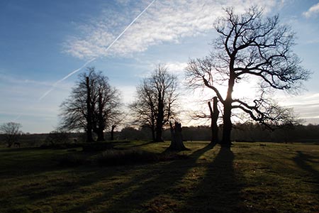
Click image to visit gallery of 6 images.
Sevenoaks is a town in Kent to the south east of London, 21 miles from Charing Cross. This route uses Sevenoaks railway station (grid ref. TQ522553) on the South Eastern Main Line as the start and end point. Knole Park (a scenic thousand-acre deer park) is a highlight of the walk and the route passes through parts of it. Walkers should be aware that there is also a golf course in the park and so care needs to be taken in places to be alert to this and to stay on the paths.
Exit Sevenoaks station and cross London Road at the lights. Turn right and take the first road on the left, St Botolph's Road, leading uphill to a green area known as The Vine. Bear right along High Street and either of the next two turnings on the left, Suffolk Way or Buckhurst Lane will lead you down to Knole Park, passing a children's playground on the right.
You can either skirt round or walk over the hill of Echo Mount where Knole House can be seen beyond the car park. Walk down to Duchess Walk, a straight road initially, and follow the road round to the right as it leads uphill in a north easterly direction to exit the park through Godden Wood. On exiting the woods, cross the next road, Park Lane, and continue downhill past a green on the right with the Bucks Head pub overlooking the green. Follow the road ahead at the foot of the green as far as Hall Hill, a country lane. Turn left here along this narrow country lane. By going this way you avoid the alternative nearby route via the Wildernesse Golf Club, but it does mean you need to be careful of any oncoming traffic until you leave the road at the next public footpath on the right just past Oak Bank Hall, going uphill through woodland.
Turning right at the next path junction, the route heads through woodland in a south-easterly direction for the next mile or so via Seal Chart to emerge on Church Road. Turn right along the road passing the church on your left. The route continues through more woodland with an off-road path ahead. To reach Stone Street Road, look out for a path off downhill to the right. However, if you miss this turning and emerge on Pine Tree Lane instead, to get back on track is a simple matter of walking along Pine Tree Lane to the right as far as the road junction and then turning right. Take the next public footpath on the left leading down to another road, Mote Road.
As the name may suggest, this is the location of the National Trust property, Ightham Mote, and people may be seen having a leisurely stroll round the gardens below to your left. Turn right at the next road turning which passes Mote Farm on the left. This is a metalled road initially, but it becomes a track later. You are now on part of the Greensand Way and you follow it for the next few miles all the way back to, and through part of Knole Park. The route passes along the side of a sloping hillside and there are frequent distant views of the landscape to the south. When you pass Carter's Hill, the route dog legs to the right to skirt a field before a short stretch of woodland and a road crossing, then you are back at Knole Park. This time you re-join the park to the south east and follow a track heading due north-west. Back in now familiar surroundings around Knole House and Echo Mount, the walk concludes by returning to Sevenoaks station.
Other walks nearby
| Walk 1510 | Otford, Romney Street & Woodlands | moderate | 14.5 miles |
| Walk 1610 | Otford, Romney Street & Kemsing | mod/hard | 16.8 miles |
| Walk 3598 | Knockholt via Pratt's Bottom, Mace Farm and The Washneys | easy/mod | 7.3 miles |
| Walk 2156 | Lullingstone Castle Circular | easy | 4.0 miles |
| Walk 2333 | Lullingstone & Preston Hill near Shoreham (Kent) | easy/mod | 6.6 miles |
| Walk 2011 | Chartwell from Crockham Hill | easy | 2.8 miles |
| Walk 2427 | Hever & Markbeech from Chiddingstone | easy | 5.9 miles |
| Walk 2284 | Limpsfield Circular | easy/mod | 6.0 miles |
| Walk 2210 | Holly Hill & Coldrum Long Barrow | easy/mod | 5.0 miles |
| Walk 2683 | Farthing Downs and Happy Valley from Coulsdon South | easy/mod | 6.0 miles |
Recommended Books & eBooks
Walking in Kent
 A guidebook describing 40 walks in the county of Kent. Covering west Kent and The Weald and north and east Kent, including the Kent Downs and the Greensand Hills. Walks of 5 to 9 miles explore rivers and coastline, beautiful countryside and historic villages. With outlines of 11 longer walks ranging from 15 to 163 miles.
More information
Messaging & Social Media
Message Walking Britain and follow the latest news.

Mountain Weather
Stay safe on the mountains with detailed weather forecasts - for iOS devices or for Android devices.