Walk 3443 - printer friendly version
Chalfont & Latimer, Latimer and Flaunden Walk
Author - Peter Smyly
Length - 13.7 miles / 22.3 km
Ascent - 1050 feet / 318 metres
Grade - moderate
Start - OS grid reference SU996975
Lat 51.6674590 + Long -0.5612265
Postcode HP6 6RZ (approx. location only)
This Buckinghamshire walk in the Chilterns route revisits some previously-visited public footpaths and bridleways in the Chilterns as described in other walk descriptions on this website as well as exploring some new ones.
As the route visits Flaunden Bottom twice, there is an option on the second occasion, to shorten the walk by way of a more direct return to the starting point. A number of public footpath signposts on the walk helpfully tell you where the path is going and how far it is, though this is not always the case as sometimes a sign simply says "public footpath".
Some sections of the walk pass along country lanes and although traffic tends to be infrequent, it is important to be alert to oncoming vehicles or cyclists and to move off the road accordingly.
A section of the Chess Valley is one of the more scenic parts of the walk, particularly the view looking down on the Great Water and the surrounding area. When I did this walk in June 2018, I counted at least ten swans on the water while, in the other direction a little further up the hill from the path, a wedding was taking place at Latimer House on the hill overlooking the water and the valley, a romantic setting. Much of the rest of the walk comprises woodland, fields, farmland and country lanes. Paths can be muddy depending on recent weather conditions though in June 2018 any potentially muddy paths were dry and rock hard with cracked mud appearing in a number of places.
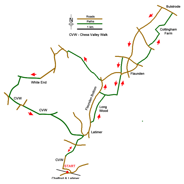
From Chalfont and Latimer tube station, exit the station from the westbound platform and go down a flight of steps ahead to reach Bedford Avenue, turn left and then right along Chenies Avenue, going straight ahead at the crossroads. At the end of the road, follow a path down through woodland, diagonally right and then at the bottom, turn left as the path emerges from the woods to go downhill to a road and then across a field to reach a bridge over a river with the weir of the Great Water on the left, a view paralleled by that of a river on the right. Follow the lane uphill to the right and then at the top of the hill take the road down into Latimer village with its green and memorial cross. Turn left here along the country lane leading into the shallow valley of Flaunden Bottom and take the first signed public footpath on the right leading uphill. As height is gained, and woodland entered, glimpses between trees to the left can be seen of the valley or "bottom" below. Follow the path all the way to Flaunden village, emerging by the church.
The next section is an optional loop since the walk later returns to the woods overlooking Flaunden Bottom.
Passing the church on the left, follow the road ahead for a short distance and continue along a footpath to Long Lane. Turn right along the road and go ahead at the crossroads, passing the Bricklayers Arms pub. Leave this road when a path appears through woods on the left, part of the Chiltern Way. Turn left on reaching Holly Hedges Lane. Take the next path on the right which skirts Cottingham Farm. At the next road, bear left and then left again down Flaunden Lane. This is one of the stretches of the walk where care needs to be taken with occasional traffic. Back at the crossroads at Flaunden, bear right to rejoin the public footpath that leads back to Flaunden Church.
Now reverse the route taken earlier back towards Long Wood but this time, when a signed path appears on the right, going downhill through woodland leading back to Flaunden Bottom, take this. This is Public Bridleway 9 and is 3/4 of a mile from Flaunden.
At the foot of the hill, there is a choice of ways to continue. Ashridge Road is nearer (if taking this route, turn left and then right) but this way involves following a road. A pleasanter route involves turning right but the drawback of this is that it is a longer walk along the road of Flaunden Bottom to reach that point which necessitates being mindful of oncoming traffic and there is a blind corner at the end just before you leave the road to continue along the bridleway on the left.
Continue along the bridleway to the left going uphill to begin with and entering woodland before crossing an open field. When the track reaches Ashridge Road turn right and then take the next road on the left downhill to a T-junction with a grassy island. Turn left uphill and continue ahead for 500 metres to a fork in the road. Fork right and walk along White End Lane to reach White End Farm. The onward route is an enclosed bridleway to the left of the farm. Continue along Green Lane for about 750 metres to the first junction where you turn left onto a bridleway heading downhill into the Chess Valley.
At the bottom of the hill, turn left and continue along the Chess Valley Walk with the river on your right. Continue on the path to reach Frith Wood on your left. Nearing the end of the wood you reach a path junction. The Chess Valley Walk veers left. You should take the right-hand fork and continue into a large field. The path follows the left-hand edge of the field with fine views overlooking the valley below on your right and the long body of water called the Great Water. The path descends to a path junction which you passed during the early stages of the walk. Turn right and retrace your route along the Chess Valley Walk back to the start.
Messaging & Social Media
Message Walking Britain and follow the latest news.

Mountain Weather
Stay safe on the mountains with detailed weather forecasts - for iOS devices or for Android devices.