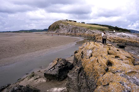
Humphrey Head from Allithwaite
Cumbria Walk
County/Area - Cumbria - South Cumbria
Author - Ian Henderson
Length - 4.0 miles / 6.5 km Ascent - 250 feet / 76 metres
Time - 2 hours 20 minutes Grade - easy
Maps 

| Ordnance Survey Explorer OL7 | Sheet Map | 1:25k | BUY |
| Anquet OS Explorer OL7 | Digital Map | 1:25k | BUY |
Walk Route Description
Click image to see photo description.
This Cumbria walk starts from the village of Allithwaite which lies just to the west of Grange over Sands. The route visits the limestone outcrop of Humphrey Head which offers wide ranging views over Morecambe Bay and the surrounding hills.
Limited parking is available on the Jack Hill below the Pheasant Inn (grid ref. SD386761). (If you intend to patronise the Inn, then I am sure you will be allowed to park if you ask permission before leaving your car.) The start of the walk is poorly signed. However, take the drive signed "Blenket Farm". This leads through a small farmyard and continues as a concrete drive. Ahead you can see Humphrey Head. The drive soon becomes rougher After 300 metres at a waymark, turn right off the driveway Continue through a field with hedge on your left to a ladder stile. Maintain direction passing barns on your left. Cross a small footbridge, go through a gate and continue with a stream on your left. Go through a kissing gate, then a squeeze stile with an adjacent signpost.
Cross farm access track to a stile. Continue through some trees. Pass through gates to go under the railway line to reach Wyke Farm. Go through a small gate on the left and then follow the path (with wall on your right). Turn right at a kissing gate to join a track between a hedge and a wall. Continue ahead onto a tarmac drive (note - you will return to this point later). Continue over the spine of Humphrey Head (grid ref. SD388747). The path generally stays on the west side amongst limestone crags with leads to the OS trig point. From here you have a fine view across Morecambe Bay and many Lakeland Hills including the Coniston Fells, Langdale Pikes and Helvellyn. If you have the energy you can clamber down to Humphrey Head Point.
Retrace your steps north along the path to reach the tarmac drive. Turn left to a Holy Well Lane. Turn right along the lane, pass the entrance to Wyke Farm following the lane as it bends sharp left. Continue to a road junction. Turn right, use the level to cross the railway. On your right you can see Wraysholme Tower, which is now part of the farm. The tower dates from the 14th century and was used to protect the farm from raiders. Continue along the lane past the farm entrance on the right and continue for just 200 metres turn right onto a signed public footpath to Allithwaite. Go through kissing gate and continue to another kissing gate. Continue ahead by a stream on your left. Turn left and cross the bridge using a concrete bridge and continue through a gate to reach a tarmac drive. Turn right, and shortly after right again to follow a driveway to Beckside and the main road. Turn right back to the start.
Other walks nearby
| Walk 2543 | Silverdale, Hawes Water & Jenny Brown's Point | easy | 7.0 miles |
| Walk 3592 | Birkrigg Common and Bardsea | easy | 3.8 miles |
| Walk 2481 | Arnside Knott Circular | easy/mod | 6.0 miles |
| Walk 2511 | Silverdale & Arnside | easy/mod | 8.0 miles |
| Walk 3549 | Whitbarrow Scar from Mill Side | moderate | 6.5 miles |
| Walk 3199 | Whitbarrow Fell from Mill Side | moderate | 7.0 miles |
| Walk 3234 | Gummers How via Chapel House Wood, South Lake District | easy/mod | 5.5 miles |
| Walk 1417 | Astley's Plantation & Simpson's Ground | easy/mod | 7.5 miles |
| Walk 1045 | Levens Bridge to Kendal | easy/mod | 11.5 miles |
| Walk 2143 | Whitbarrow & Lord's Seat | easy/mod | 5.4 miles |
Recommended Books & eBooks
Walking the Lake District Fells - Keswick
 Part of the Walking the Lake District Fells series, this guidebook covers a wide range of routes to 30 Lakeland summits that can be climbed from Keswick, Whinlatter, Bassenthwaite, Caldbeck, Mungrisdale and Threlkeld, with highlights including Skiddaw and Blencathra. Includes suggestions for longer ridge routes.
More information
Walking the Lake District Fells - Wasdale
 Part of the Walking the Lake District Fells series, this guidebook covers a wide range of routes to 25 Lakeland summits that can be climbed from the Wasdale, Eskdale and Ennerdale valleys, with highlights including Scafell Pike, Great Gable and Pillar. Suggestions for longer ridge routes are also included.
More information
Messaging & Social Media
Message Walking Britain and follow the latest news.

Mountain Weather
Stay safe on the mountains with detailed weather forecasts - for iOS devices or for Android devices.