Abbeystead Reservoir Circular from Stoops Bridge
Forest of Bowland Walk
Region - Forest of Bowland
County/Area - Lancashire
Author - Lou Johnson
Length - 1.6 miles / 2.6 km Ascent - 150 feet / 45 metres
Time - 1 hours 0 minutes Grade - easy
Maps 

| Ordnance Survey Explorer OL41 | Sheet Map | 1:25k | BUY |
| Anquet OS Explorer OL41 | Digital Map | 1:25k | BUY |
Walk Route Description
Click image to see photo description.
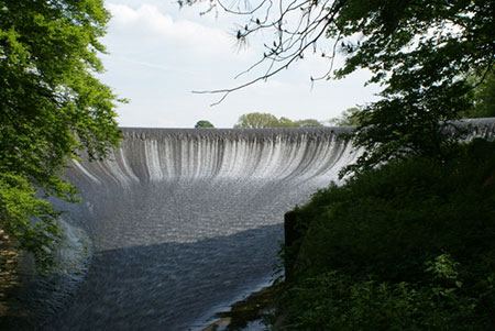
An easy Lancashire walk from Stoops Bridge in the beautiful Wyre Valley. The route offers excellent views of the reservoir and dam before passing through the immaculate estate village of Abbeystead. After rain, the path through Hinberry Wood can be muddy.
The start is the small car park by Stoops Bridge by the River Wyre (grid ref. SD563544). After parking walk south along the lane with the river on your right. After 200 metres you cross the Marshaw Wyre River, a tributary of the Wyre. Turn right off the lane following a permissive path through Hinberry Wood. The path soon runs alongside the reservoir and continues to pass the dam. Continue ahead to reach a footbridge. Turn right and cross the river.
Once across the river, bear right and follow the Wyre Way initially alongside the reservoir before turning right to reach Abbeystead Lane at a ladder stile. Turn right along the lane and walk downhill and through the village. Pass the village school on your left and you are soon back at the start.
Other walks nearby
| Walk 1742 | Grit Fell from the Jubilee Tower near Quernmore | moderate | 7.7 miles |
| Walk 2164 | Clougha Pike from the Jubilee Tower | easy/mod | 4.7 miles |
| Walk 3038 | Wolfhole Crag from Tower Lodge | moderate | 9.0 miles |
| Walk 2257 | Clougha Pike from Quernmore | easy/mod | 4.8 miles |
| Walk 2137 | Clougha & Goldsworthy's Installation Circular | moderate | 5.2 miles |
| Walk 1218 | Fiensdale Head & Bleasdale Water | moderate | 10.0 miles |
| Walk 2594 | Totridge Fell & Fiendsdale Head, Forest of Bowland | moderate | 11.0 miles |
| Walk 1670 | Hazelhurst Fell, Fair Snape Fell and Parlick | moderate | 11.0 miles |
| Walk 1994 | Cockerham, Glasson & Conder Green | easy/mod | 6.6 miles |
| Walk 3505 | Whitewell via Crag Stones from Dunsop Bridge | easy/mod | 8.5 miles |
Recommended Books & eBooks
Walking in the Forest of Bowland and Pendle
 A guidebook to 40 diverse circular day walks suitable for walkers with navigational skills. The Forest of Bowland and Pendle are two of north west England's upland AONBs, perfect for walkers who enjoy exploring rough hilly, sometimes pathless terrain. The routes include Ward's Stone, Pendle Hill, Longridge Fell and Fair Snape Fell.
More information
Walking on the West Pennine Moors
 This guidebook describes 30 walks on the West Pennine Moors, around Blackburn, Darwen, Chorley and Bolton, home to some of the most inspiring and exhilarating walking country. The walks range from short, easy rambles to more challenging hikes covering a variety of terrain, all of it easily accessible for day walking.
More information
Messaging & Social Media
Message Walking Britain and follow the latest news.

Mountain Weather
Stay safe on the mountains with detailed weather forecasts - for iOS devices or for Android devices.