Walk 3459 - printer friendly version
Abbeystead Reservoir Circular Walk
Author - Lou Johnson
Length - 1.6 miles / 2.6 km
Ascent - 150 feet / 45 metres
Grade - easy
Start - OS grid reference SD563544
Lat 53.9837940 + Long -2.6678864
Postcode LA2 9BH (approx. location only)
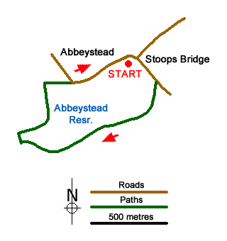
An easy Lancashire walk from Stoops Bridge in the beautiful Wyre Valley. The route offers excellent views of the reservoir and dam before passing through the immaculate estate village of Abbeystead. After rain, the path through Hinberry Wood can be muddy.
The start is the small car park by Stoops Bridge by the River Wyre (grid ref. SD563544). After parking walk south along the lane with the river on your right. After 200 metres you cross the Marshaw Wyre River, a tributary of the Wyre. Turn right off the lane following a permissive path through Hinberry Wood. The path soon runs alongside the reservoir and continues to pass the dam. Continue ahead to reach a footbridge. Turn right and cross the river.
Once across the river, bear right and follow the Wyre Way initially alongside the reservoir before turning right to reach Abbeystead Lane at a ladder stile. Turn right along the lane and walk downhill and through the village. Pass the village school on your left and you are soon back at the start.
Messaging & Social Media
Message Walking Britain and follow the latest news.

Mountain Weather
Stay safe on the mountains with detailed weather forecasts - for iOS devices or for Android devices.