Corndon Tor & Yar Tor Circular
Dartmoor Walk
Nat Park - Dartmoor
County/Area - Devon
Author - Lou Johnson
Length - 4.3 miles / 7 km Ascent - 750 feet / 227 metres
Time - 2 hours 50 minutes Grade - easy/mod
Maps 

| Ordnance Survey Explorer OL28 | Sheet Map | 1:25k | BUY |
| Anquet OS Explorer OL28 | Digital Map | 1:25k | BUY |
Walk Route Description
Click image to see photo description.
This Dartmoor walk lies to the north-west of Ponsworthy in South Devon. The route explores an area of moors and tors with ample evidence of Bronze Age settlements. During the walk you can enjoy some fine views especially to the south to Sharp Tor and the Dart Valley beyond.
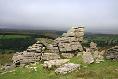
The start is the off-road parking area (grid ref. SX681763) on the minor road from Bellever to Ponsworthy at the northern end of Compton Down. After parking head south along a path with a wall on your left. When the wall ends maintain direction across rising ground to follow a ridge which leads after a small depression to the summit of Corndon Tor (grid ref. SX6865742). From here you can enjoy the view south with the rocky summit Sharp Tor to the south. Beyond lies the Dart Valley and rolling landscape of South Devon.
From the summit ridge, continue by heading half right on a clear path that descends south-west to the road below with Yar Tor rising beyond the road. During the descent you pass the Cave-Penney Memorial Cross, which commemorates the bravery of a First World War soldier. Cross the road and continue on a clear path to the summit of Yar Tor (grid ref. SX678739). From here the view west offers a different perspective of the landscape with the village of Dartmeet below.
To continue take the path south west down towards Dartmeet. Follow the path for about 600 metres to reach a cross path (grid ref. SX674736). If you wish you can extend the walk by descending to Dartmeet, where the East Dart and West Dart rivers join. If you take this option return to this point to continue the route.
From the path junction, turn right and continue on a rising path across the western flank of Yar Tor. The path initially heads north but then veers slightly right to reach a gate on the boundary of open access land (grid ref. SX677745). Continue north through along the path with the wall on your left. The path drops slight to cross a stream and then bears left to head north to a ladder stile on the lane near Sherwell (grid ref. SX678750). Turn right along the road.
Continue past the farm on your right, follow the road to the right and then turn left up a track by a wall and fingerpost. Follow the clear track for some 600 metres to enter a walled field. Go half right across the field still on the track to the far left-hand corner. Continue through a gate for a short distance with a wall on your left. Reaching the end of the wall, bear left and follow a distinct path/track. This path soon bears right and continues back to the start.
Other walks nearby
| Walk 3201 | Bellever Tor & Postbridge | easy/mod | 5.5 miles |
| Walk 3202 | Postbridge & Challacombe Down from Bellever | moderate | 9.8 miles |
| Walk 2838 | Laughing Tors | easy | 3.5 miles |
| Walk 3463 | Sharp Tor, Corndon Tor & Yar Tor Circular | easy/mod | 3.4 miles |
| Walk 1772 | Hurston, Lettaford & Two Moors Way | moderate | 8.6 miles |
| Walk 3757 | Buckland in the Moor Circular | easy/mod | 6.3 miles |
| Walk 3458 | Sharrah Pool from New Bridge | easy | 3.4 miles |
| Walk 3460 | Dr Blackall's Drive & Ponsworthy | easy/mod | 6.8 miles |
| Walk 1260 | Haytor Rocks & Hound Tor from Saddle Tor | moderate | 7.5 miles |
| Walk 1657 | Huntingdon Warren & Lud Gate from Scorriton | moderate | 7.0 miles |
Recommended Books & eBooks
No suggestions for this area.Messaging & Social Media
Message Walking Britain and follow the latest news.

Mountain Weather
Stay safe on the mountains with detailed weather forecasts - for iOS devices or for Android devices.