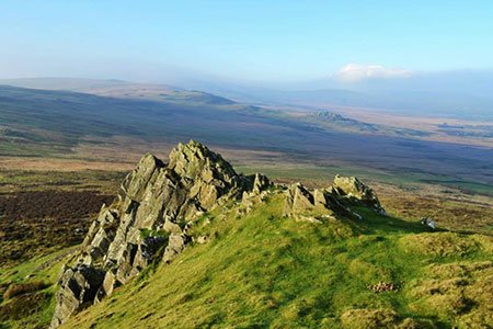
Foel Drygarn Hillfort, Preseli Hills
Pembrokeshire Coast Walk
Nat Park - Pembrokeshire Coast
County/Area - Pembrokeshire
Author - Lou Johnson
Length - 1.8 miles / 2.9 km Ascent - 350 feet / 106 metres
Time - 1 hours 20 minutes Grade - easy
Maps 

| Ordnance Survey Explorer OL35 | Sheet Map | 1:25k | BUY |
| Anquet OS Explorer OL35 | Digital Map | 1:25k | BUY |
Walk Route Description
Click image to see photo description.
This short Pembrokeshire walk up to the Iron Age hillfort of Foel Drygarn takes you to most easterly summit of the Preseli Hills. As you near the summit, the path gets steeper, but you soon are rewarded for your efforts as you able to enjoy one of the finest views in this beautiful part of West Wales. It is worth noting that the Preseli Hills are part of the Pembrokeshire Coast National Park and on a clear day you can see this often rugged coast.
The start is a layby (grid ref. SN165331) on a minor road near Blaenbanon which lies just over a kilometre west from the A478, south of Crymych. Note the parking area has limited capacity and you may need to park elsewhere on busy days.
After parking, cross the road and follow the waymarked track north. The track is enclosed by hedges and leads to a gate with an adjacent information board, which gives a potted history of the area and hillfort. Go through the gate and follow the wall on your right. A short way along the wall a grassy path heads half left up the hill. Follow this to the summit.
The summit area has the remains of the hillfort and an OS trig column (363 metres above sea level). Spend some time enjoying the 360-degree panorama. Don't forget to the explore the remains of this substantial hillfort. To return to the start, take the clear path heading south from the trig point to the left-hand corner of a plantation. Descend to the plantation and turn left along a wide grassy track. This is the Golden Road which crosses the main ridge of the Preseli Hills. Continue to the gate used on the outward leg of the walk. Follow the enclosed track back to the start.
Other walks nearby
| Walk 3466 | The Preseli Ridge along the Golden Road | moderate | 6.4 miles |
| Walk 3465 | Foel Eryr Circular, Preseli Hills | moderate | 6.0 miles |
| Walk 3469 | Foel Cwmcerwyn from Rosebush, Preseli Hills | moderate | 5.0 miles |
| Walk 3494 | Pwllygranant & Cebwr Bay from Moylgrove | mod/hard | 8.5 miles |
| Walk 2291 | Mynydd Carningli from Newport | easy/mod | 4.5 miles |
| Walk 3490 | Cemaes Head & Clawddcam from Poppit Sands | moderate | 8.3 miles |
| Walk 3491 | Cwm yr Esgyr & Cemaes Head from Poppit Sands | moderate | 6.1 miles |
| Walk 3474 | Dinas Island from Cwm-yr-Eglwys | easy | 3.0 miles |
| Walk 2193 | Penbryn & Llangrannog Circular | easy/mod | 5.4 miles |
| Walk 2250 | Penbryn & Tresaith | easy/mod | 3.5 miles |
Recommended Books & eBooks
The Wales Coast Path
 A single guidebook to walking the whole Wales Coast Path - 1400km (870 miles) the length of Wales from Chester to Chepstow, including Anglesey, described in 57 stages. The route passes through the Snowdonia and Pembrokeshire National Parks and many AONBs and can be linked with the Offa's Dyke Path for a complete circuit of Wales.
More information
Messaging & Social Media
Message Walking Britain and follow the latest news.

Mountain Weather
Stay safe on the mountains with detailed weather forecasts - for iOS devices or for Android devices.