Tardebigge Flight of Locks, Bromsgrove
Worcestershire Walk
County/Area - Worcestershire
Author - Lou Johnson
Length - 5.3 miles / 8.6 km Ascent - 340 feet / 103 metres
Time - 3 hours 0 minutes Grade - easy
Maps 

| Ordnance Survey Explorer 204 | Sheet Map | 1:25k | BUY |
| Anquet OS Explorer 204 | Digital Map | 1:25k | BUY |
Walk Route Description
Click image to see photo description.
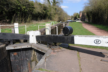
The highlight of this Worcestershire walk on the eastern outskirts of Bromsgrove is the Tardebigge Locks on the Worcester and Birmingham Canal. The flight of 30 locks raises the level of the canal over 220 feet. The walk passes all the locks in the flight from lock 29 at Stoke Pound to lock 58 after which the canal passes through a tunnel. The section of canal was opened in the early 1800's and was built to link Birmingham with the River Severn at Worcester.
The start is the Tardebigge village carpark (grid ref. SO995691) which lies just off the B4184 southeast of Bromsgrove. After parking, exit the car park and turn right along Church Lane. Pass St Bartholomew's Church on your right and continue around the back of the school to join the Monarch's Way as it turns left to reach High House Lane. Turn right along this lane and continue to a T-junction.
At the T-junction go straight ahead to join a signed bridleway. Follow the track with the hedge on your right. Follow the clear track for a kilometre. Just before Patchett's Farm, bear left off the track to follow a clear footpath across a field. The path then crosses a much larger field. It then crosses a smaller field to reach a grassy area. Turn left and follow the path around the edge of the next field and through trees to reach Copyholt Lane (grid ref. SO978674). Turn right along Copyholt Lane and continue, with care, for two kilometres to reach the Worcester and Birmingham Canal at Stoke Pound.
Just before the canal bridge, bear right down the tarmac path to towpath. Turn right along the canal (which should be on your left). The walk now follows the canal for about three kilometres to pass all thirty locks. Soon after joining the towpath you pass lock 29. Only 29 more to go! As you make progress you will pass Tardebigge Reservoir on your right, which was used to supply water to canal system. Reaching lock 58 you have reached the last lock in this impressive example of civil engineering. Just beyond this lock, turn right onto the signed Monarch's Way which will take you back to the start.
Other walks nearby
| Walk 1006 | Hanbury Hall & Piper's Hill Circular | easy | 5.5 miles |
| Walk 3461 | Hanbury Park from Piper's Hill circular | easy | 5.3 miles |
| Walk 1501 | Lickey Hills, Barnt Green and the Bittell Reservoirs | easy | 4.5 miles |
| Walk 3716 | Morton Bagot & Bannam's Wood from Studley | easy/mod | 8.4 miles |
| Walk 3235 | Studley Circular | easy/mod | 8.3 miles |
| Walk 3681 | New End & Cladswell Circular | easy | 3.5 miles |
| Walk 3715 | Holberrow Green & New End from Inkberrow | easy/mod | 8.3 miles |
| Walk 3702 | Coughton Circular | easy/mod | 6.8 miles |
| Walk 3686 | Dormston from Inkberrow Circular | easy | 5.4 miles |
| Walk 1345 | Alcester Town & Country Circular | easy/mod | 7.0 miles |
Recommended Books & eBooks
No suggestions for this area.Messaging & Social Media
Message Walking Britain and follow the latest news.

Mountain Weather
Stay safe on the mountains with detailed weather forecasts - for iOS devices or for Android devices.