Strumble Head & Garn Fawr Hillfort
Pembrokeshire Coast Walk
Nat Park - Pembrokeshire Coast
County/Area - Pembrokeshire
Author - Lou Johnson
Length - 6.8 miles / 11.1 km Ascent - 1000 feet / 303 metres
Time - 4 hours 20 minutes Grade - moderate
Maps 

| Ordnance Survey Explorer OL35 | Sheet Map | 1:25k | BUY |
| Anquet OS Explorer OL35 | Digital Map | 1:25k | BUY |
Walk Route Description
Click image to see photo description.
This Pembrokeshire walk explores an interesting landscape in the vicinity of the Garn Fawr hillfort, before following paths and tracks to reach the coast east of Strumble Head. The route then turns west and follows the Pembrokeshire Coast Path around Strumble Head. The final section of the walk is an ascent of Garn Fawr from where you can see most of the walk you have just completed.
The walk starts from the small car park to the east of Garn Fawr (grid ref. SM899388). After parking, exit the car park, cross the lane, and follow the path opposite with the wall on your left. After a few minutes you reach open country with the rocky outcrop of Garn Fechan ahead. Follow the path which passes to the left-hand side of the outcrop. Just after reaching a smaller outcrop on the right, the path divides. Take the left-hand fork and follow the path which soon runs parallel to a wall on your left. Go left through the gap in the wall to reach a track. Turn right.
Follow the enclosed track ahead. After 600 metres the track bends left and then right and continues with a wall on your left to reach T-junction (grid ref. SM 912392). Turn left and follow the enclosed track north to pass to the left of Trenewydd to reach a road at a metal gate (grid ref. SM912397). Turn left and then right onto a signed footpath (sign in hedge on the right) through a metal gate and onto a clear track. After 350 metres the track turns right, and short way ahead turns left. You soon pass the house at Goodhope on your left.
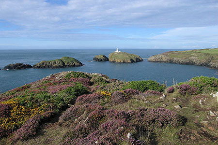
The track doglegs right and left through some trees and then continues north towards the sea passing to the left of a house at Penrhyn to reach the Pembrokeshire Coast Path at a wooden gate. Turn left and follow this well-signed trail along the coast. During the next 2.5 kilometres you can enjoy a relaxing walk passing through a number of gates along the way. The rugged coast keeps your interest as the path undulates along the cliffs dropping to the shoreline at one point.
You get glimpses of the Strumble Head lighthouse before reaching the point where path runs below a road (up on your left). The path crosses the road (grid ref. SM895412) and continues in a southerly direction. Stay on the coast path for just over 4 kilometres enjoying the beautiful coastal scenery until you reach a lane (grid ref. SM893388). Cross the road and take the waymarked left-hand driveway following it as it bends to the right. Continue straight ahead to join the path climbing onto Garn Fawr. The path climbs steeply to the right of an obvious crag to reach the summit. The descending path follows a wall (on your left) down to the carpark below.
Other walks nearby
| Walk 3481 | Carregwastad Point & Strumble Head Circular | moderate | 7.7 miles |
| Walk 1434 | Abercastle & Trefin Circular | moderate | 7.5 miles |
| Walk 3477 | Porthgain, Abereiddi Bay & Blue Lagoon | easy | 3.7 miles |
| Walk 3474 | Dinas Island from Cwm-yr-Eglwys | easy | 3.0 miles |
| Walk 3476 | Porthgain & Blue Lagoon from Abereiddy | easy/mod | 6.5 miles |
| Walk 2291 | Mynydd Carningli from Newport | easy/mod | 4.5 miles |
| Walk 2056 | Pointz Castle from Solva | easy/mod | 5.5 miles |
| Walk 3466 | The Preseli Ridge along the Golden Road | moderate | 6.4 miles |
| Walk 3465 | Foel Eryr Circular, Preseli Hills | moderate | 6.0 miles |
| Walk 1997 | St. David's & Coast Path Circular | moderate | 9.7 miles |
Recommended Books & eBooks
The Wales Coast Path
 A single guidebook to walking the whole Wales Coast Path - 1400km (870 miles) the length of Wales from Chester to Chepstow, including Anglesey, described in 57 stages. The route passes through the Snowdonia and Pembrokeshire National Parks and many AONBs and can be linked with the Offa's Dyke Path for a complete circuit of Wales.
More information
Messaging & Social Media
Message Walking Britain and follow the latest news.

Mountain Weather
Stay safe on the mountains with detailed weather forecasts - for iOS devices or for Android devices.