Walk 3479 - printer friendly version
Strumble Head & Garn Fawr Hillfort Walk
Author - Lou Johnson
Length - 6.8 miles / 11.1 km
Ascent - 1000 feet / 303 metres
Grade - moderate
Start - OS grid reference SM899388
Lat 52.0077640 + Long -5.0626300
Postcode SA64 0JJ (approx. location only)
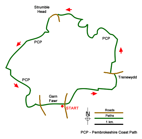
This Pembrokeshire walk explores an interesting landscape in the vicinity of the Garn Fawr hillfort, before following paths and tracks to reach the coast east of Strumble Head. The route then turns west and follows the Pembrokeshire Coast Path around Strumble Head. The final section of the walk is an ascent of Garn Fawr from where you can see most of the walk you have just completed.
The walk starts from the small car park to the east of Garn Fawr (grid ref. SM899388). After parking, exit the car park, cross the lane, and follow the path opposite with the wall on your left. After a few minutes you reach open country with the rocky outcrop of Garn Fechan ahead. Follow the path which passes to the left-hand side of the outcrop. Just after reaching a smaller outcrop on the right, the path divides. Take the left-hand fork and follow the path which soon runs parallel to a wall on your left. Go left through the gap in the wall to reach a track. Turn right.
Follow the enclosed track ahead. After 600 metres the track bends left and then right and continues with a wall on your left to reach T-junction (grid ref. SM 912392). Turn left and follow the enclosed track north to pass to the left of Trenewydd to reach a road at a metal gate (grid ref. SM912397). Turn left and then right onto a signed footpath (sign in hedge on the right) through a metal gate and onto a clear track. After 350 metres the track turns right, and short way ahead turns left. You soon pass the house at Goodhope on your left.
The track doglegs right and left through some trees and then continues north towards the sea passing to the left of a house at Penrhyn to reach the Pembrokeshire Coast Path at a wooden gate. Turn left and follow this well-signed trail along the coast. During the next 2.5 kilometres you can enjoy a relaxing walk passing through a number of gates along the way. The rugged coast keeps your interest as the path undulates along the cliffs dropping to the shoreline at one point.
You get glimpses of the Strumble Head lighthouse before reaching the point where path runs below a road (up on your left). The path crosses the road (grid ref. SM895412) and continues in a southerly direction. Stay on the coast path for just over 4 kilometres enjoying the beautiful coastal scenery until you reach a lane (grid ref. SM893388). Cross the road and take the waymarked left-hand driveway following it as it bends to the right. Continue straight ahead to join the path climbing onto Garn Fawr. The path climbs steeply to the right of an obvious crag to reach the summit. The descending path follows a wall (on your left) down to the carpark below.
Messaging & Social Media
Message Walking Britain and follow the latest news.

Mountain Weather
Stay safe on the mountains with detailed weather forecasts - for iOS devices or for Android devices.