Walk 3486 - printer friendly version
Sutton Cheney & Market Bosworth Walk
Author - Lou Johnson
Length - 7.4 miles / 12 km
Ascent - 420 feet / 127 metres
Grade - easy/mod
Start - OS grid reference SP411994
Lat 52.5908530 + Long -1.3947436
Postcode CV13 6DS (approx. location only)
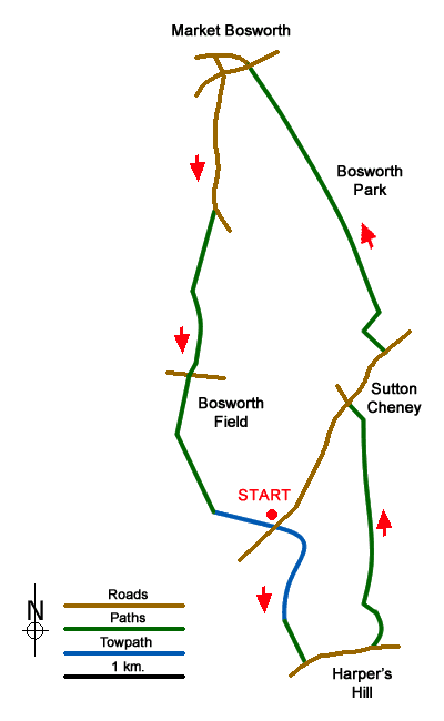
This Leicestershire walk explores the area to the south of Market Bosworth which includes Bosworth Park, the village of Sutton Chaney and the battlefield of Bosworth Field where Richard II lost his crown to Henry Tudor in 1485. The start is the car park beside the Ashby de la Zouch canal at Sutton Wharf (grid ref. SP411994), which lies south-west of Sutton Cheney.
After parking, exit the car park and turn right over the canal. Once over the bridge, turn right and descend to the towpath. Turn right under the bridge and continue with the canal to your left. Continue along the towpath to the first bridge (bridge 33) where you leave the canal and follow the waymarked Leicestershire Round path across fields to a metal kissing gate on Stapleton Lane (grid ref. SP413982). Turn left along the lane and continue for 600 metres to pass New House Farm on the left. Just past the farm entrance, turn left over a stile by a yellow marker post.
The onward path heads north crossing agricultural land. The route is marked with yellow way markers and after two kilometres reaches Twenty Acre Lane in Sutton Cheney (grid ref. SK418002). Turn left along the lane and then right along Main Street. Stay on Main Street to reach the Royal Arms Hotel on the left. Turn left into the carpark following the fingerpost on the right-hand side of the road (grid ref. SK419008). Continue along the Leicestershire Round heading north across a field. The path then turns right along the edge of the next field (hedge on your right) before heading half left to enter Bosworth Park.
Continue past Spring Wood on your right, cross a track leading to Woodhouse Farm, also on your right and continue between trees. One kilometre after passing Woodhouse Farm you reach Bow Pool which is on your right. Continue straight ahead through Bosworth Country Park to reach a road (The Park). Turn left and continue along Rectory Lane heading towards the town centre. Stay on Rectory Lane to reach a T-junction (grid ref. SK406030).
Turn south (left) into Sutton Lane. You soon reach a gate where you continue straight ahead. Continue along the lane for a further kilometre and turn right across a small footbridge at a fingerpost (grid ref. SK406019). The route ahead is waymarked with yellow posts and arrows. The path leads across fields to Ambion Lane (grid ref. SK404006). Go straight across and join the tarmac lane opposite signed to Bosworth Battlefield. Keep straight ahead passing the summit of Ambion Hill on the left and the Heritage Centre on your right. You now are following the Leicestershire Round again. The path, enters Ambion Wood, Continue through a dogleg and onto the canal. Bear left and follow the path with the canal on your right and return to Sutton Wharf carpark.
Messaging & Social Media
Message Walking Britain and follow the latest news.

Mountain Weather
Stay safe on the mountains with detailed weather forecasts - for iOS devices or for Android devices.