Cwm yr Esgyr & Cemaes Head from Poppit Sands
Pembrokeshire Coast Walk
Nat Park - Pembrokeshire Coast
County/Area - Pembrokeshire
Author - Lou Johnson
Length - 6.1 miles / 9.9 km Ascent - 1100 feet / 333 metres
Time - 4 hours 10 minutes Grade - moderate
Maps 

| Ordnance Survey Explorer OL35 | Sheet Map | 1:25k | BUY |
| Anquet OS Explorer OL35 | Digital Map | 1:25k | BUY |
Walk Route Description
Click image to see photo description.
This Pembrokeshire walk from Poppit Sands explores the valley of Cwm yr Esgyr using tracks and footpaths to reach the coast at Pwyllgranant. The route then follows the often-precipitous Pembrokeshire Coast Path which rises to over 500 feet above the sea to reach Cemaes Head. The walk then descends along a quiet lane back to the start.
The walk starts from the pay and display car park behind the beach at Poppit Sands (grid ref. SN152485). After parking walk through the car park away from the café to reach the eastern exit. Turn right up the lane and continue uphill, steeply in places, for just under 1.5 kilometres. Where the road bends to left (grid ref. SN143480) take the narrow lane straight ahead (no through road). After a short distance bear left down a track (bridleway fingerpost on the right).
The track climbs gently across the side of Cwn yr Esgyr to pass a chapel. Continue for 400 metres beyond the chapel and turn left down a track. Follow this down to the edge of woodland and turn right along the edge of the field with the trees to your left. After 120 metres head half left down through trees to reach a track (grid ref. SN131480). Bear right along the track towards Gernos Farm. Before reaching the farm, turn left down an enclosed grassy track (grid ref. SN129479). This soon bends right and continues past woodland on your right. Near the end of the trees the track turns left. At this point continue straight ahead on a footpath across a field with the hedge on your left. Continue through a gap into a second field and maintain direction across grass to a track.
Bear left along the track and almost immediately turn right onto a footpath which passes in front of a house (Graig). Follow the path with hedge on your left down to a stream. Follow the stream (on your left) through trees. Exiting the trees take the next path on the left and continue to reach the Pembrokeshire Coast Path at a three-way fingerpost (grid ref. SN123478).
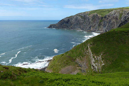
Turn right along the coast path and head north with the sea to your left. The path, often precipitous with a head for heights needed on occasions, climbs steadily, levels off and then climbs again with an excellent view ahead of the steep rocky cliffs. At the top of this climb you reach the highest point of the coast path on this section with a fine retrospective view south along the coast. The path undulates to reach Cemaes Head where it turns east. Another lofty section of path takes you above the cliffs. As you make progress a view towards the Teifi estuary opens ahead. A descent takes you to Allt-y-coed farm where you continue along their access drive to join a lane.
One final climb out of the valley and you have about two kilometres of downhill walking back to the start enjoying a good view across Poppit Sands and the Teifi Estuary. Reaching the Lifeboat Station bear right, and the car park is on your right with refreshments available in season at the adjacent café.
Other walks nearby
| Walk 3494 | Pwllygranant & Cebwr Bay from Moylgrove | mod/hard | 8.5 miles |
| Walk 2291 | Mynydd Carningli from Newport | easy/mod | 4.5 miles |
| Walk 2193 | Penbryn & Llangrannog Circular | easy/mod | 5.4 miles |
| Walk 2250 | Penbryn & Tresaith | easy/mod | 3.5 miles |
| Walk 3468 | Foel Drygarn Hillfort, Preseli Hills | easy | 1.8 miles |
| Walk 3467 | Foel Drygarn Hillfort circular, Preseli Hills | easy/mod | 3.7 miles |
| Walk 3474 | Dinas Island from Cwm-yr-Eglwys | easy | 3.0 miles |
| Walk 3493 | Llangrannog Circular | easy/mod | 4.5 miles |
| Walk 3466 | The Preseli Ridge along the Golden Road | moderate | 6.4 miles |
| Walk 3465 | Foel Eryr Circular, Preseli Hills | moderate | 6.0 miles |
Recommended Books & eBooks
The Wales Coast Path
 A single guidebook to walking the whole Wales Coast Path - 1400km (870 miles) the length of Wales from Chester to Chepstow, including Anglesey, described in 57 stages. The route passes through the Snowdonia and Pembrokeshire National Parks and many AONBs and can be linked with the Offa's Dyke Path for a complete circuit of Wales.
More information
Messaging & Social Media
Message Walking Britain and follow the latest news.

Mountain Weather
Stay safe on the mountains with detailed weather forecasts - for iOS devices or for Android devices.