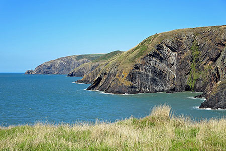
Pwllygranant & Cebwr Bay from Moylgrove
Pembrokeshire Coast Walk
Nat Park - Pembrokeshire Coast
County/Area - Pembrokeshire
Author - Lou Johnson
Length - 8.5 miles / 13.8 km Ascent - 1400 feet / 424 metres
Time - 5 hours 40 minutes Grade - mod/hard
Maps 

| Ordnance Survey Explorer OL35 | Sheet Map | 1:25k | BUY |
| Anquet OS Explorer OL35 | Digital Map | 1:25k | BUY |
Walk Route Description
Click image to see photo description.
This energetic Pembrokeshire walk explores the countryside and coast north of Moylgrove (Trewyddel). The route crosses rolling agricultural land using paths, tracks, and lanes to reach the coast at Pwllygranant. From here the dramatic Pembrokeshire Coast Path (also the Wales Coast Path) is used south to Ceibwr Bay reaching over 500 feet above the sea in places.
The start is the small car park on the south side of the road in Moylgrove (grid ref. SN118447). After parking exit the car park and turn right across a small stone bridge. Where the main road bends to the left take the side road signed to Glanrhyd. Continue up the lane passing a small cemetery and church on the left. 300 metres beyond the church, turn left at a fingerpost (hidden in the hedge) and cross a stile. Walk half right across the field to a stile in the hedge. Cross a smaller field with hedge on your left to another stile. Go straight across the next field, ignoring the path on the left. Maintain direction across three more fields keeping a wood to your left in the third field.
Reaching a lane (grid ref. SN131439), turn left and descend to cross a stone bridge. Continue uphill along the lane. After 600 metres, just beyond a bungalow, turn left onto a track (fingerpost on the left a few metres from the lane). Follow the track as it bends left and continue straight ahead for a kilometre, ignoring a cross track in woodland and another track on the left, to reach a T-junction (grid ref. SN135450). Turn left and follow the track around the right of Pantsaeson Farm. The track bends right, left, right and then gently curves to the left. After 300 metres take the footpath on the left (grid ref. SN129454). Follow this path straight across the field to reach a track. Bear left and almost immediately right to pass to the right of the farm buildings. Follow the farm access drive to reach a lane (grid ref. SN122454).
Turn left and continue to where the road bears left. Continue straight ahead on a gravel track. Follow the track as it soon bends right. Pass through Morawelon and continue ahead to reach Cwm Connell after the track bends left. Continue ahead along a concrete track past Seaview Cottage on your left to reach Tre-Rhys where you turn right between farm buildings. Turn left and take the track to the immediate right of a white cottage. This track initially heads north and then swings right to join a better track (grid ref. SN120470). Continue ahead along the track to the next junction after 300 metres. Turn left towards Hendre Farm and immediately sharp right onto a little used footpath. Cross several fields towards some trees. Locate the stile and continue into a large field. Keep to the left-hand edge and continue through a gap to join a track.
Turn left along the track. Reaching a house (Graig), bear left in front of the house and follow the path with hedge on your left down to a stream. Turn right up the stream (on your left) through trees. Exiting the trees take the next path on the left and continue to reach the Pembrokeshire Coast Path at a three-way fingerpost (grid ref. SN123478).
Turn left along the coast path with the sea to your right. A steep ascent takes you onto the cliff top with an excellent view north. This section of the coast path sees few walkers and the grassy path makes walking a pleasure. In places the path is quite precipitous, and care is needed. Rounding the headland at Pen yr Afr you have a fine view south along the cliffs. The path undulates above the cliffs soon crossing a wooden footbridge and a short section of boardwalk. The view ahead includes Dinas Island and Strumble Head. After more ups and downs, the path turns inland, crosses a track, and turns right to pass a row of bungalows. The path then descends quite steeply to Ceibwr Bay where a slab bridge takes you across a stream and left up to a tarmac lane (grid ref. SN1104560). Turn right at the first junction and continue up to a road.
A short diversion to the right offers a grandstand view along the coast you have just walked. After a few metres, follow the signed coast path and continue until you reach an open grassy area from where you can enjoy the view. Continue up to re-join the road and turn left. You now have 1.5 kilometres of road walking back to Moylgrove. Reaching the main road, turn left and the car park used at the start is a short way along on the right.
Other walks nearby
| Walk 3490 | Cemaes Head & Clawddcam from Poppit Sands | moderate | 8.3 miles |
| Walk 3491 | Cwm yr Esgyr & Cemaes Head from Poppit Sands | moderate | 6.1 miles |
| Walk 2291 | Mynydd Carningli from Newport | easy/mod | 4.5 miles |
| Walk 3474 | Dinas Island from Cwm-yr-Eglwys | easy | 3.0 miles |
| Walk 3468 | Foel Drygarn Hillfort, Preseli Hills | easy | 1.8 miles |
| Walk 3467 | Foel Drygarn Hillfort circular, Preseli Hills | easy/mod | 3.7 miles |
| Walk 3466 | The Preseli Ridge along the Golden Road | moderate | 6.4 miles |
| Walk 3465 | Foel Eryr Circular, Preseli Hills | moderate | 6.0 miles |
| Walk 3469 | Foel Cwmcerwyn from Rosebush, Preseli Hills | moderate | 5.0 miles |
| Walk 2193 | Penbryn & Llangrannog Circular | easy/mod | 5.4 miles |
Recommended Books & eBooks
The Wales Coast Path
 A single guidebook to walking the whole Wales Coast Path - 1400km (870 miles) the length of Wales from Chester to Chepstow, including Anglesey, described in 57 stages. The route passes through the Snowdonia and Pembrokeshire National Parks and many AONBs and can be linked with the Offa's Dyke Path for a complete circuit of Wales.
More information
Messaging & Social Media
Message Walking Britain and follow the latest news.

Mountain Weather
Stay safe on the mountains with detailed weather forecasts - for iOS devices or for Android devices.