St. Govan's Chapel, Bosherston & Elegug Stacks
Pembrokeshire Coast Walk
Nat Park - Pembrokeshire Coast
County/Area - Pembrokeshire
Author - Lou Johnson
Length - 9.6 miles / 15.6 km Ascent - 600 feet / 182 metres
Time - 5 hours 20 minutes Grade - moderate
Maps 

| Ordnance Survey Explorer OL36 | Sheet Map | 1:25k | BUY |
| Anquet OS Explorer OL36 | Digital Map | 1:25k | BUY |
Walk Route Description
Click image to see photo description.
This Pembrokeshire walk explores the area west of Bosherston using the Pembrokeshire Coast Path (part of the Wales Coast Path). The route crosses part of the Castle Martin firing range which is used for 44 weeks of the year when this route is closed for access. During holiday periods and some weekends, the route can be completed. For further information visit www.gov.uk/government/publications/castlemartin-firing-notice--2 or call 01646 662367 for recorded information. Whilst on the range DO NOT touch spent ammunition or any suspicious objects.
The walk starts from St. Govan's Chapel car park (grid ref. SR967930) which lies on the coast south of Bosherston village. After parking follow the road back to Bosherston and continue through the village passing the church on your right. As the road descends you reach the start of a wood on your right. Just after this point, bear left through a metal gate to join the Pembrokeshire Coast Path (inland route). The track passes a quarry on your right and shortly after you reach a junction with a gate across the road ahead. Turn right here on the rising track to turn left by an information board and gate. The path soon turns right and follows the right-hand boundary and continues crossing a track. Cross the track and continue along the left-hand edge of woodland. At the end of the wood, turn left and follow the hedge on your right across three field to re-join the concrete track.
Turn right along the track and almost immediately right through metal gates to join a track. Reaching a junction by a chapel on your right, bear left and then follow the lane around to the right to join the B4319. Turn left and continue for just over a kilometre through Merrion to a crossroads. Turn left (signed to Stack Rocks) and continue for 2.5 kilometres across the range to reach the car park at Stack Rocks (grid ref. SR926946).
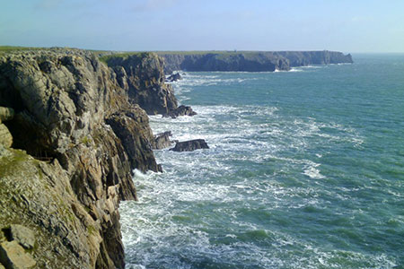
Leave the car park at the right-hand end and follow a grassy path to the viewing platform above the Green Bridge of Wales which is a slender arch that leads out to an offshore stack. Having taken in the view head east along the Pembrokeshire Coast Path with the sea on your right. You soon pass the Elegug Stacks and the associated caves, coves, and blowholes just beyond. Care is needed here as the cliff is sheer and unprotected. In places the Pembrokeshire Coast Path follows a course way from the cliff top. However, it is worth following the path closest to the cliff top to avoid missing the many points of interest.
Continue along the path above Flimston Bay, past Moody Nose with its Iron Age fort to skirt around Bullslaugher Bay. After Mewsford Point there is another arch and many other dramatic features. The Castle promontory is the site of another Iron Age fort. Continuing along the coast you reach Huntsman's Leap, a long narrow cove. You soon reach the car park used at the start of the walk. It is worth continuing a short distance to visit St. Govan's Chapel before heading home.
Other walks nearby
| Walk 3366 | Bosherston Lily Ponds | easy | 3.4 miles |
| Walk 3365 | Bosherston Lily Ponds, Broad Haven & St. Govan's Chapel | easy/mod | 5.0 miles |
| Walk 3364 | The Stackpole Estate from Stackpole Quay | easy | 5.0 miles |
| Walk 3498 | Freshwater West & Angle | moderate | 8.7 miles |
| Walk 3363 | Swanlake Bay from Manorbier | easy/mod | 4.8 miles |
| Walk 3497 | Angle Peninsula | easy | 3.7 miles |
| Walk 3475 | Caldey Island Circular | easy | 3.0 miles |
| Walk 3496 | St Anne's Head & Dale Peninsula | easy/mod | 7.0 miles |
| Walk 1209 | Saundersfoot & Tenby | easy/mod | 4.5 miles |
| Walk 2485 | Broad Haven & Druidston Circular | easy/mod | 4.9 miles |
Recommended Books & eBooks
The Wales Coast Path
 A single guidebook to walking the whole Wales Coast Path - 1400km (870 miles) the length of Wales from Chester to Chepstow, including Anglesey, described in 57 stages. The route passes through the Snowdonia and Pembrokeshire National Parks and many AONBs and can be linked with the Offa's Dyke Path for a complete circuit of Wales.
More information
Messaging & Social Media
Message Walking Britain and follow the latest news.

Mountain Weather
Stay safe on the mountains with detailed weather forecasts - for iOS devices or for Android devices.