Freshwater West & Angle
Pembrokeshire Coast Walk
Nat Park - Pembrokeshire Coast
County/Area - Pembrokeshire
Author - Lou Johnson
Length - 8.7 miles / 14.1 km Ascent - 1100 feet / 333 metres
Time - 5 hours 30 minutes Grade - moderate
Maps 

| Ordnance Survey Explorer OL36 | Sheet Map | 1:25k | BUY |
| Anquet OS Explorer OL36 | Digital Map | 1:25k | BUY |
Walk Route Description
Click image to see photo description.
This Pembrokeshire Coast walk starts from the beach at Freshwater West and the follows the undulating cliff top path north and past Rat Island. The path drops down to West Angle beach before following the road through Angle village to re-join the Pembrokeshire Coast Path on the east side of the Angle Peninsula. The final part of the route turns inland and returns to the start.
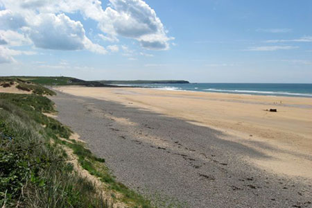
The start is the car park at the southern end of Freshwater West beach (grid ref. SR886995). After parking, cross the B4319 and bear right onto the beach. Exposed to the wind the beach is popular with surfers and windsurfers. The path runs along the foot of the dunes with the sea to your left. Continue along the sand for a kilometre to locate a sandy path on the right that soon veers left to follow the Pembrokeshire Coast Path.
The path becomes more demanding as its meanders along the low cliffs with many ascents and descents along the way. The views ahead and behind are ever changing. The view ahead soon includes St Ann's Head across the mouth of Milford Haven. Pass the natural arch at Guttle Hole, continue around Whitedole Bay and a view to Sheep Island.
The route continues past Castles Bay to reach the impressive blowhole of Welcome Pit. Soon after, you pass above Rat Island with the path swinging east. West Angle Beach comes into view with Thorn Island off the headland. Continue on the path descending to West Angle beach. Reaching the car park you have a choice. You can extend the walk by continuing around the Angle Peninsula by following Walk 3497. To continue this walk, turn right down the lane (grid ref. SM854031) and continue ahead through the village of Angle.
Where the road bends to the right, continue ahead along a no through road. Reaching a gate, continue ahead onto a private drive with the sea alongside to your left. The drive bends to the right and soon after bends left. Soon after the drive heads right and fingerpost marks the point where you leave the drive and continue on the coast path. Pass a wooden barrier and turn right along a gravel track. This leads to a lane. Bear left along the lane and continue for 800 metres to reach the B4320.
Turn left and after 400 metres take the signed path through a metal gate, which is before the Rocket Cart Cottage on the left. Follow the path with hedge right across the first field. Entering the next field head very slightly left to cross a stile on the far side. Drop down to a small stream and bear right to reach the Pembrokeshire Coast Path. Turn left and retrace your steps along the Wales Coast Path (also the Pembrokeshire Coast Path) back to the start.
Other walks nearby
| Walk 3497 | Angle Peninsula | easy | 3.7 miles |
| Walk 3365 | Bosherston Lily Ponds, Broad Haven & St. Govan's Chapel | easy/mod | 5.0 miles |
| Walk 3496 | St Anne's Head & Dale Peninsula | easy/mod | 7.0 miles |
| Walk 3495 | St. Govan's Chapel, Bosherston & Elegug Stacks | moderate | 9.6 miles |
| Walk 3366 | Bosherston Lily Ponds | easy | 3.4 miles |
| Walk 3364 | The Stackpole Estate from Stackpole Quay | easy | 5.0 miles |
| Walk 3473 | Marloes Peninsular Circular | easy/mod | 7.0 miles |
| Walk 3362 | Marloes Sands Circular | easy | 4.5 miles |
| Walk 3367 | Nab Head & Musselwick Sands from Marloes | easy/mod | 6.2 miles |
| Walk 2485 | Broad Haven & Druidston Circular | easy/mod | 4.9 miles |
Recommended Books & eBooks
The Wales Coast Path
 A single guidebook to walking the whole Wales Coast Path - 1400km (870 miles) the length of Wales from Chester to Chepstow, including Anglesey, described in 57 stages. The route passes through the Snowdonia and Pembrokeshire National Parks and many AONBs and can be linked with the Offa's Dyke Path for a complete circuit of Wales.
More information
Messaging & Social Media
Message Walking Britain and follow the latest news.

Mountain Weather
Stay safe on the mountains with detailed weather forecasts - for iOS devices or for Android devices.