Freshwater West & Angle Walk
Walk 3498 - Route Maps & Profile
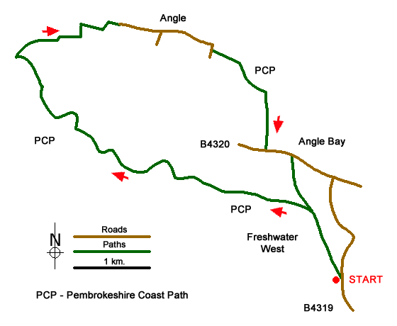
Route Map
Digital Maps - Copyright © 2011-2024. All rights reserved.
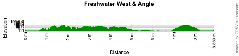
Route Profile
Sketch Map
Suggested Maps 

| Ordnance Survey Explorer OL36 | Sheet Map | 1:25k | BUY |
| Anquet OS Explorer OL36 | Digital Map | 1:25k | BUY |
It is recommended you take a map. The preferred scale is 1:25k.
Start Point Details
Ordnance Survey Grid Ref SR886995
Latitude 51.654433 Longitude -5.057531
Postcode SA71 5AH
what3words start townhouse.flexed.firepower
Walk description may contain detailed information on the start point for this walk.
Further Information
Pembrokeshire Coast
Walking in the Pembrokeshire Coast National Park is Britain's only truly coastal national park. Rimmed by a spectacular waterscape of rugged cliffs, sandy beaches and wooded estuaries, the land rises to wild inland hills. This environment is a place of sanctuary for wildlife who share the landscape that has been shaped by many people over the centuries. Tombs and castles, crosses and cottages, quarries and quays are all reminders of man's endeavours, which remains a working landscape. Inland the Preseli Hills offer excellent walking across the moorland ridge. Pembrokeshire Coast Walking Guide
Pembrokeshire
Pembrokeshire is home to the Pembrokeshire Coast National Park, which is the only national park in United Kingdom established because of the coastline. In addition to the glorious coastline, The Preseli Hills in the north of the national park also offer excellent walking. The Preseli Hills are an area of high moorland with Foel Cwmcerwyn (536 m.) the highest point. The 190-mile (310 km) Pembrokeshire Coast Path offers a challenging route allowing you to explore the magnificent coast. Outside the national park boundaries, you can enjoy rural countryside.
Walk grading - Learn how each walk is assessed and select a walk to suit your ability and experience by going to Walk Grading Details.
Messaging & Social Media
Message Walking Britain and follow the latest news.

Mountain Weather
Stay safe on the mountains with detailed weather forecasts - for iOS devices or for Android devices.