Ingleborough (northern approach) from Chapel-le-Dale
Yorkshire Dales Walk
Nat Park - Yorkshire Dales - Three Peaks Country
County/Area - North Yorkshire
Author - Allan Friswell
Length - 9.5 miles / 15.4 km Ascent - 2000 feet / 606 metres
Time - 6 hours 50 minutes Grade - moderate
Maps 

| Ordnance Survey Explorer OL2 | Sheet Map | 1:25k | BUY |
| Anquet OS Explorer OL2 | Digital Map | 1:25k | BUY |
| Ordnance Survey Landranger 98 | Sheet Map | 1:50k | BUY |
| Anquet OS Landranger 98 | Digital Map | 1:50k | BUY |
Walk Route Description
Click image to visit gallery of 9 images.
This Yorkshire Dales walk ascends Ingleborough in distinct sections. The initial ramble is straightforward, but the ascent of the hill itself is reminiscent of the stairs that Frodo climbed over the mountains in "Lord of the Rings". From the summit the descent is straightforward if irregular underfoot, and the final leg, parallel with the river Doe along the former Roman road, is easy. The views from the summit remain, as ever, magnificent.
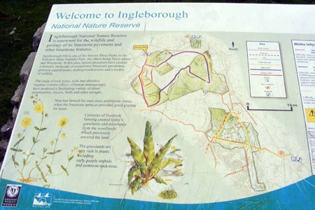
From the car park at grid ref. SD746778 go down past the Hill Inn and after a small stone building belonging to Yorkshire Water turn left over the stile whose signpost points to Great Douk and Ingleborough. Follow the obvious path, passing the huge Braithwaite Wife Hole. You are walking through the Ingleborough Nature Reserve. Continue via a duckboarded track to the western base of the hill where an extremely steep ascent eventually gets you on to the plateau.
Make your way up and then along it to the trig point on Ingleborough's summit at 2,372 feet above sea level. Whernside is ahead behind Twistleton Crags to the north and Pen-y-Ghent is to the east. You will also see the curving Ribblehead Viaduct taking the Settle and Carlisle Railway over 24 arches of masonry, the longest if not the tallest viaduct in the UK. On a clear day you can also see ahead, in the far distance, the peaks of the Lake District, and Morecambe Bay due west. Notice the great pile of stones nearer the Ingleton edge. This is the ruins of a 'hospice', a building erected in 1830 and largely destroyed at the same time due to the drunken revelries of those celebrating its construction. Nothing changes…
Behind the cairn and walled shelter lies your clear path down SW. Follow this as far as the farm at Crina Bottom, as isolated a farm as you could hope to find. A gate, and the track becomes walled on both sides. Follow this for ½ mile to a ladder stile on the right signed to Skirwith. Cross this. Follow the left hand wall to another ladder stile. Over this and follow the r/h wall downhill, eventually reaching the B6255.
Cross the road, pass through a gate and follow the track for a few yards when a waymarked if indistinct path takes you right, over a slab bridge and through the foliage with the road to your right. Another slab bridge leads to the quarry track. Cross this and follow the clearly signed path to eventually reach a stile. Then follow the green track across the field with Beezley Farm to your left. The buildings at White Scar Caves come into your view on your right. Pass under the telegraph wires and continue along the obvious path as it turns left. Go through a broken wall to reach the river Doe. Cross this via the stile and easy-paced stepping stones just below Beezley Farm. Walk up the slope just past the farm, turn right down the tarmacked road, the old Roman Road, for two miles, with Twistleton Scars looming to your left, and Raven Scar on your right. When the track finally meets the main road (and don't fail to visit the tiny little gem of St Leonard's Church), turn left and follow it back to your car.
Other walks nearby
| Walk 1184 | Whernside & Scales Moor | moderate | 11.0 miles |
| Walk 3340 | Blea Moor & Denthead from Ribblehead | moderate | 8.2 miles |
| Walk 3032 | Gragareth & Great Coum from Yordas Cave | moderate | 9.0 miles |
| Walk 3091 | Ingleton Waterfalls Walk | easy | 4.3 miles |
| Walk 1121 | Pen-y-ghent & Plover Hill | moderate | 9.0 miles |
| Walk 1013 | Pen-y-ghent | moderate | 6.5 miles |
| Walk 1500 | Pen-y-ghent via Horton Scar | moderate | 6.8 miles |
| Walk 3433 | Yorkshire Three Peaks from Horton-in-Ribblesdale | very hard | 24.5 miles |
| Walk 2146 | Deepdale Circular (near Dent) | moderate | 7.0 miles |
| Walk 1248 | Trow Gill, Ingleborough & Long Scar | moderate | 9.5 miles |
Recommended Books & eBooks
Walking in the Yorkshire Dales: South and West
 Part of a two-book set, this guidebook describes 44 walks in the southern and western Yorkshire Dales, including the famous 23 mile Three Peaks circuit over Pen-y-Ghent, Whernside and Ingleborough. The other, mostly circular routes of 3½ to 13 miles cover the scenic region between Sedbergh, Kirkby Lonsdale, Settle, Skipton and Grassington.
More information
Walking in the Yorkshire Dales: North and East
 This guidebook contains 43 circular day walks in the north and east Yorkshire Dales. It explores the dales, hills and moors between Kirkby Stephen and Pateley Bridge. Walking ranges from gentle 3 mile strolls to more strenuous day-long rambles across the Howgills, Wensleydale, Swaledale, Nidderdale, Mallerstang and Coverdale.
More information
Messaging & Social Media
Message Walking Britain and follow the latest news.

Mountain Weather
Stay safe on the mountains with detailed weather forecasts - for iOS devices or for Android devices.