Walk 3503 - printer friendly version
Circular from Berkhamsted Walk
Author - Donald Morton
Length - 4.0 miles / 6.5 km
Ascent - 400 feet / 121 metres
Grade - easy
Start - OS grid reference SP984090
Lat 51.771036 + Long -0.57532755
Postcode HP4 1ES (approx. location only)
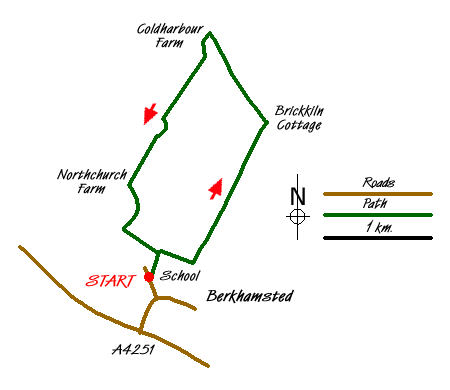
This Hertfordshire walk starts by Bridgewater School (Grid ref. SP984090). It is possible to park in Bridle Way approaching the school. Walk uphill passing the school gates on the right and continue up an enclosed footpath. On reaching a crossing path turn right through a kissing gate onto another enclosed but much broader path. At the next gate turn left and walk up the field with fence and hedge on the left. At the top of the first field do a left/right dog leg over a stile and continue walking in the same direction but now with the hedge on the right. Go through a hedge gap at the end of this field and continue still in the same direction and still with the hedge on the right. After a slight wiggle in the field edge continue over a stile, down into a Chiltern bottom - dry valley - and up the edge of the field towards woods.
At the field corner go straight on over a stile into woods. Go up to meet a bridle path. Follow the bridle path left and immediately up through the woods so that the previous direction is more or less continued. For a bridle path this is quite narrow but as it twists through the woods it is marked by white painted arrows on the trees. It comes out onto a crossing track which on the right enters the garden of Brickkiln Cottage. (Note - landowner has now closed off part of the trail meaning the route is now detoured through some very overgrown woodland to link back up with the route mapped) Go over the track and straight on into the woods the other side. The track is unmarked and ill defined but the objective is to skirt round the boundary of the cottage so keep as near as possible to this; at a cross track turn right still skirting the cottage. This track arrives at a gate into the garden. Here Turn Left and in a few yards arrive at a gravel track by a finger post. This is on the Hertfordshire Way which runs to the right and left (but is signed only to the right). Go Left - signed as part of the Ashridge Boundary Trail. The path goes about twenty or thirty yards inside the wood with a large grass expanse beyond. When the grass expanse ends the path continues through the wood in the same direction. Follow it until arriving at Great Coldharbour Farm.
Here turn left, leaving the Hertfordshire Way but still following the Ashridge Boundary Trail - the Trail way mark roundel is on the farm gatepost. Go between the farm buildings and out through a small gate with the farmhouse on the right and a pond on the left. Beyond the pond swing half left diagonally across the field aiming for a power line pole. On reaching this objective go over the stile and then follow the power line down the edge of the field with initially a thin strip of wood on the left. At the end of the field turn left through a gate onto a gravel track which goes down hill and swings right. Where it swings right again, go straight on through a gate to go up a field edge with hedge on right. At the end of this field, turn left for a few yards and then turn right through a hedge gap into another field. Cross this field diagonally left aiming for a black Dutch barn. Here go through a kissing gate and follow a gravel track with buildings on left. At the end go through another gate, forward for a few yards and then turn left, passing in front of the farm and down a public byway (red marker) through woods. On reaching houses on the left go straight on. Reaching a tarmac road turn left. After a few yards it reverts to a gravel road with houses on the left. When the houses end, go through metal barriers and turn right down the enclosed path which started the walk.

Mountain Weather
Stay safe on the mountains with detailed weather forecasts - for iOS devices or for Android devices.

