Walk 3520 - printer friendly version
Princes Risborough circular Walk
Author - Peter Smyly
Length - 9.5 miles / 15.4 km
Ascent - 1100 feet / 333 metres
Grade - easy/mod
Start - OS grid reference SP799027
Lat 51.717346 + Long -0.84482058
Postcode HP27 9DD (approx. location only)
This is a circular walk in the Chiltern Hills to the east of the town of Princes Risborough in Buckinghamshire. During the course of the walk, the scenery has a recurrent theme of woodland, fields and undulating countryside. There are a couple of steep sections, the first one approaching Brush Hill to provide the walk's finest viewpoint. Then in the latter stages, there is a steep slope down to negotiate through woodland to reach Brimmers Road via a field. Boots are recommended as there are a number of muddy sections. Several wooden stiles are also crossed on a route that includes part of the Icknield Way and the Chiltern Way. There is a conspicuous absence of any water features.
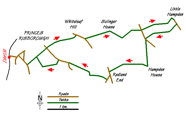
From Princes Risborough railway station, walk up Poppy Road, leading to Wycombe Road, and take the waymarked Upper Icknield Way route to the left, along a tarmac secondary road initially. After crossing New Road, follow the track ahead and take a path to the right which borders a field on the left and Whiteleaf Cross on Whiteleaf Hill comes into view in the distance to the left, beyond the hamlet of Whiteleaf. This is the one main uphill stretch of the walk. Next the path leads up through woodland before emerging onto open felllside with some grazing sheep and a road with traffic, heard but not seen, to the right. At the top of the slope is a trig point, revealing the name "Brush Hill Local Nature Reserve" with a retrospective view looking down on Princes Risborough and the countryside beyond. Continue through woodland to cross a tarmac road and branch left at the car park. Take the next footpath on the right that leads through Sergeant's Wood with a carpet of leaves underfoot. Passing Solinger House, the route leads down to a crossroads. Go straight ahead here and the distinctive rounded grassy hump of Beacon Hill appears in the distance on the left on the approach to Dirtywood Farm. Just before the farm, a permissive path to the left contours round before going straight ahead with a field on the right. Heading due east past the field, the route continues through woodland before a right turning brings you to another minor road leading to Little Hampden where there is a wooden seat on a grassy triangle. A cluster of signposts next to the green indicates that this is a meeting - or parting - of different ways.
Follow the road south-east from here which soon leads to another public footpath through woodland (with a "You are here" map on a wooden post unexpectedly appearing on the left). After going through woodland, the footpath turns right to emerge on the edge of a field where it contours round the field and then, as a footpath sign indicates, branches left downhill through woodland, before crossing another field and then resuming down through more woodland to emerge on a road. Cross the road and continue to follow the waymarked signs on the other side, now crossing a cultivated field before entering woodland. The path goes uphill at this point before emerging onto another field just before passing the mansion of Hampden House on the left. Now branch right and follow a straight course due west to south west, crossing the same combination of a cultivated field, followed by woodland. At the next road at Redland End, a left turn followed by a right turn almost immediately down the road signposted Lacey Green, continues the route. Take the next signposted turning on the right through more woodland. After a few hundred yards, what appears to be a T junction of paths is reached. However, on closer inspection, there is a barely discernible path that goes straight ahead and, which starts losing height in earnest, easily the steepest downhill stretch of the entire walk. This is a section where wooden stair treads have been built in places to make downwards progress easier. The path emerges from the woods at the bottom of the hill to cross a wooden stile to enter a field which it crosses to reach Brimmers Road. After a couple of hundred yards, take the road turning to the left downhill for a shorter distance before a path to the right leads across another field. At the end of the field, follow the path bordering the field to the right and this path leads back to the town of Princes Risborough and the walk's starting point.
Messaging & Social Media
Message Walking Britain and follow the latest news.

Mountain Weather
Stay safe on the mountains with detailed weather forecasts - for iOS devices or for Android devices.