Walk 3526 - printer friendly version
Hanging Shaw, Cronkley Scar, Low Force & High Force Walk
Author - Lou Johnson
Length - 12.7 miles / 20.6 km
Ascent - 1400 feet / 424 metres
Grade - moderate
Start - OS grid reference NY867298
Lat 54.6631050 + Long -2.2077028
Postcode DL12 0HA (approx. location only)
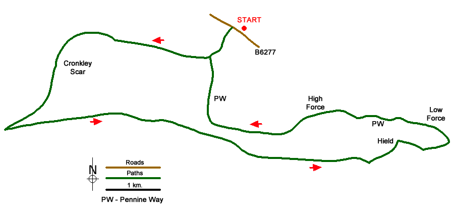
This walk explores Upper Teesdale in County Durham, taking through some wonderful scenery typical of the area. The small car park near Hanging Shaw (grid ref. NY867298) on the north side of the B6277 just under 6 miles north-west of Middleton-in-Teesdale provides an ideal place to start.
After parking exit the car park, turn right along the B6277 and in a few yards, go left down a driveway and continuing footpath to the bridge over the River Tees at grid ref. NY862293. Cross the bridge, turn right and follow the path to High House (grid ref. NY856294), Continue on the path beside the River Tees for two and quarter miles passing beneath Cronkley Scar and Raven Scar. The path is flanked by steep ground to your right for most of the way. However, after passing through a wall at grid ref. NY833287, you reach a more open area. Pass through another wall in 300 metres into an enclosed field. About half way along this field bear left through a gate and follow a clear rising path/track onto Cronkley Fell.
The way ahead goes to the left of a walled enclosure and then soon after to the right of a further three walled enclosures. You are now descending and shortly after the last enclosure a wall appears to your left. The route parallels this wall, passes Birk Rigg and heads off towards Holwick Scar. Soon the wall on your left turns north-east and you need to continue on the clear track in an easterly direction for just over a mile past some grouse butts to reach an indistinct path junction at grid ref. NY889275. Leave the track here and bear left and continue down to a track just beyond Hield House (grid ref. NY894279).
Bear right along this track for just over 400 metres. Turn left on the footpath leading down to Wynch Bridge (grid ref. NY903278). Do not cross the bridge, instead turn left along the Pennine Way (also part of the Pennine Journey) and continue past Low Force, over Keedholm Scar and past High Force. This is quite a long walk in its own right. From joining the Pennine Way at Wynch Bridge it is about four miles of riverside walking until you reach the bridge over Tees at grid ref. NY862293 which you crossed in the early stages of the walk. Cross the bridge and retrace your route back to the B6277. Turn right and the car park is a little way along this road on your left.
Messaging & Social Media
Message Walking Britain and follow the latest news.

Mountain Weather
Stay safe on the mountains with detailed weather forecasts - for iOS devices or for Android devices.