Cop Mere and the Offleys
Staffordshire Walk
County/Area - Staffordshire - Mid Staffordshire
Author - Daryl Smith
Length - 7.0 miles / 11.4 km Ascent - 330 feet / 100 metres
Time - 3 hours 50 minutes Grade - easy
Maps 

| Ordnance Survey Explorer 243 | Sheet Map | 1:25k | BUY |
| Anquet OS Explorer 243 | Digital Map | 1:25k | BUY |
Walk Route Description
Click image to visit gallery of 3 images.
This is an easy stroll through quietly lovely countryside in a hidden backwater of rural Staffordshire. Our route is based on the tiny hamlet of Copmere End, home to the Star Inn and tucked away to the west of the pleasant town of Eccleshall. The name Offley is thought to derive from clearings in woodland owned by Offa, King of Mercia.
Copmere End is best approached from the B5026 north-west of Eccleshall, turn off at the brown "tourist sign" for the Star Inn. There is limited roadside parking near the start of the route; if you are intending to visit the Star and phone ahead you should be able to use the pub car park. There are benches on the Millennium Green at Offley Marsh if you want to rest-up or picnic.
This walk is in an area crisscrossed with a web of narrow lanes and paths; your OS map will offer a myriad of options to extend the basic route or even to take short-cuts. Our route is a mix of field paths and very quiet country lanes.
The start of this Staffordshire walk is at Copmere End (grid ref. SJ803294). The walk starts from a ladder stile about 200 metres north-east of the crossroads in front of the Star Inn; climb over the stile and follow a path along the hedge line around the northern side of Copmere.
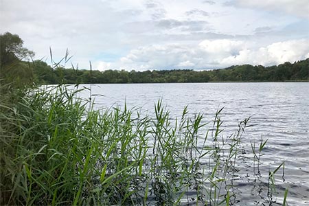
Copmere is an attractive reed fringed lake scoured out by glaciation and fed by the headwaters of the River Sow, it is a haven for wildlife and a designated SSSI. The local angling club has unfortunately found it necessary to close off the entrance to public access; we can only view the lake through trees on its northern and southern edges.
After passing through open fields you will come to a narrow path crossing a stream that has been dammed to create a series of ponds, turn right in front of the stile and follow the hedge line to a kissing gate on your left (see note below*). Go through the gate onto a permissive path through the Sugnall Estate. Past a pond and out into an open field, turn right and follow the hedge line on your right through another two gates, after the second gate go diagonally left up a slight incline to Sugnall. Turn right here and after the second gate go left through another gate, down a lovely path down through woodland past St. Catherine's Well and a series of pools. You will return to the line of the public footpath that you were previously following, turn right and continue to Walk Mill.
On arrival into the lane at Walk Mill, it is well worth a very short detour left to view the delightful mill pond. There is an incongruous lintel in the south gable of the derelict fulling mill shed on the opposite side of the lane to the pond - it originates from demolition of an ill-fated palace built at nearby Gerard's Bromley to accommodate "Good Queen Bess" (she never turned up!).
Returning to our route, go around Mill House and along the lane. Rather than continue on the lane you have an option to visit two small nature reserves, Jackson's Marsh and Jackson's Coppice, both full of wildflowers in season. There is a boardwalk around the Marsh to keep your feet dry and the Coppice is full of bluebells in spring (take care to avoid badger latrines!). The Marsh is accessed through a small car park on your left and you can then cross a field to the Coppice.
Follow the lane along the river bottom and over a crossroads into Offleybrook. Soon, on your left is Offley Mill one of the last three commercially operating watermills in the country and counts a royal Duchy amongst its customers. Continue on the lane past the large mill pond to an area known as Outlands. Just over the infant river turn left on a driveway then right between houses, over two stiles go left past a pond and across fields to Bishop's Offley.
If you do wish to extend your walk, Outlands would be a good starting point. Langot Valley ahead offers good walking with excellent views deep into the Shropshire Hills from the top of its eastern flank above Daddy's Barn Farm; enter Bishop's Wood opposite the farm and explore to find impressionist sculptures and remains of an ancient glass furnace.
At the outskirts of Bishop's Offley go briefly right on the lane then left up steps to access a field path, follow the path as it loops round the field headland then go left over a stile. Into the next field there are two stiles in the right-hand hedge, take either of these stiles and cross the field to Offley Marsh. At Offley Marsh you emerge onto a lane close to a junction, cross over to take the lane opposite passing the Millennium Green and the last remnants of natural marshland.
Beyond the marsh, keep right at the junction with a grass triangle and follow the lane to a crossroads. Less than a mile ahead beyond the crossroads but pretty well hidden by trees is Garmelow Manor once home to Arnold Machin - you may not recognise his name, but this Stoke-on-Trent born sculptor's artworks are the most reproduced in history. Turn left at the crossroads but take time to look behind you as you go over the crest on the lane, wide ranging views to the south belie the modest elevation.
Follow the lane through Offleyhay as far as the village hall then go through a gate and across the car park to access a field path down the hill. Emerging onto the lane, turn right and walk past the southern side of Copmere back to your starting point.
Note At time of writing the permissive path through the Sugnall Estate was open. If the path is not open at the time of your visit, simply continue on the right-of-way to Walk Mill.
Other walks nearby
| Walk 2499 | Aqualate Mere & Forton | easy/mod | 8.0 miles |
| Walk 1837 | Norbury Junction Circular | easy | 4.6 miles |
| Walk 2269 | Norbury Junction, Gnosall & Aqualate Mere | easy/mod | 8.1 miles |
| Walk 2353 | Aqualate Mere & Sutton | easy | 5.2 miles |
| Walk 1941 | Outwoods & Beffcote | easy | 4.1 miles |
| Walk 2917 | Downs Banks near Barlaston | easy | 2.5 miles |
| Walk 3591 | Derrington circular from Stafford Castle | easy | 3.6 miles |
| Walk 2099 | Stafford - a town centre stroll | easy | 1.5 miles |
| Walk 2842 | Sandon Park from Salt | easy | 4.6 miles |
| Walk 1394 | Bednall & Acton Trussell from near Stafford | easy | 6.5 miles |
Recommended Books & eBooks
Walking in the Peak District - White Peak East
 Guidebook describing 42 half-day and day walks in the limestone landscapes of Derbyshire's White Peak, part of the Peak District National Park. One of two volumes, this book covers the east of the region, with potential bases including Bakewell, Eyam, Castleton, Birchover, Matlock and Wirksworth.
More information
Messaging & Social Media
Message Walking Britain and follow the latest news.

Mountain Weather
Stay safe on the mountains with detailed weather forecasts - for iOS devices or for Android devices.