Walk 3535 - printer friendly version
River Dee from Farndon Walk
Author - Lou Johnson
Length - 4.0 miles / 6.5 km
Ascent - 150 feet / 45 metres
Grade - easy
Start - OS grid reference SJ413545
Lat 53.0844760 + Long -2.8778259
Postcode CH3 6QU (approx. location only)
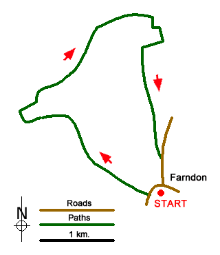
This short Cheshire walk starts from the village of Farndon which lies on the east bank of the River Dee. The River Dee forms the boundary between England and Wales and by this stage the river meanders across the flood plain.
The start is the free car park which lies behind the Parish Memorial Hall in the centre of the village (grid ref. SJ413545). Exit the car park and turn right along Church Lane. Continue along the lane with the churchyard on your right. Reaching a junction, go straight ahead down a tarmac path (signed no vehicles). This leads you to the High Street. Turn left and continue down to the river Dee. (An interesting diversion from the main route is to turn left following the riverbank for about half a mile to the remains of Holt Castle, which are across the river. If you take this option return along the path to bridge.)
The main route takes the signed footpath on the right just before crossing the river bridge. Follow this path keeping the River Dee on your left. The path follows the meandering course of the river for just under one and a half miles to reach Willows Fish Farm (grid ref. SJ399566). Follow the path past the Fish Farm to reach Townfield Lane. Go straight across to regain the riverside path to enter woodland. After 400 metres of woodland walking you reach a path junction (grid ref. SJ405563).
Turn right here, leaving the riverside path, soon exiting the woods. Join an enclosed track (Knowl Lane). After 350 metres turn right at a signpost (grid ref. SJ411564). Follow the track along the left-hand side of the field (with the field boundary to your left). The track bends right and then left to reach some barns (grid ref. SJ413561). Turn right between the barns and follow the track to a T-junction. Turn left and follow track south for 200 metres to a junction of tracks (grid ref. SJ411559).
Go ahead to join an enclosed track heading south. Follow this path/track south for about one kilometre to reach a road (grid ref. SJ413548). Continue ahead down the road which will lead you back to the centre of Farndon village.
Messaging & Social Media
Message Walking Britain and follow the latest news.

Mountain Weather
Stay safe on the mountains with detailed weather forecasts - for iOS devices or for Android devices.