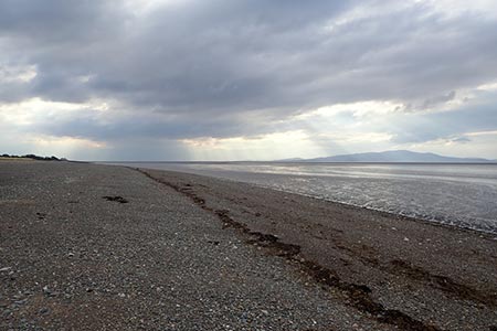
Grune Point from Silloth
Cumbria Walk
County/Area - Cumbria - North Cumbria
Author - Lou Johnson
Length - 4.7 miles / 7.6 km Ascent - 50 feet / 15 metres
Time - 2 hours 20 minutes Grade - easy
Maps 

| Ordnance Survey Explorer OL4 | Sheet Map | 1:25k | BUY |
| Anquet OS Explorer OL4 | Digital Map | 1:25k | BUY |
| Ordnance Survey Landranger 85 | Sheet Map | 1:50k | BUY |
| Anquet OS Landranger 85 | Digital Map | 1:50k | BUY |
Walk Route Description
Click image to see photo description.
This Cumbria walk starts from the small seaside resort and port of Silloth which overlooks the Solway Firth and Southern Scotland. The route offers expansive views across the Firth and on a clear day there are views to Criffel in Dumfries and Galloway (570 metres). In season the area is home to a wide variety of birds.
The start is the central car park, The Pines, on the seafront (grid ref. NY110540). After parking walk the short distance to the promenade and turn right. Continue along the seafront, with the sea on your left, passing a lighthouse on stilts. Continue following the path soon reaching Skinburness. The path then goes behind some houses still following the seashore. At Skinburnessbank (grid ref. NY124560) the path doglegs left and then right. The onward path signed 'Grune Point' crosses a sandy area before leaving the shore and following the boundary of a number of fields on your right.
The meandering path is easy to follow and soon Grune Point (grid ref. NY143568) is reached with the Solway Firth to your left. The route then swings right through 180 degrees and then follows the northern edge of Grune Point Nature Reserve with Skinburness Creek on your immediate left. Follow the shoreline to reach a clear track with field boundaries on your immediate right.
Follow this track for just under a mile to reach a lane (grid ref. NY128558). Turn right along the lane and follow it as it turns sharp left. Continue along the lane for 600 metres to regain the promenade used on the outward leg of the walk. Retrace your steps along the promenade back to the start.
Other walks nearby
| Walk 1177 | Great Sca Fell via Trusmadoor | moderate | 6.5 miles |
| Walk 3283 | Great Cockup and Meal Fell from Longlands | moderate | 6.0 miles |
| Walk 2390 | High Pike from Fell Side | moderate | 5.2 miles |
| Walk 2612 | Roughton Gill, Caldbeck Fells | easy | 4.5 miles |
| Walk 2244 | Whitewater Dash and Great Calva | moderate | 7.0 miles |
| Walk 1676 | Ullock Pike, Long Side and Carl Side | moderate | 5.5 miles |
| Walk 3316 | Rockcliffe to Kippford | easy | 3.0 miles |
| Walk 3290 | Rockcliffe to Sandyhills | easy/mod | 5.0 miles |
| Walk 2040 | Ullock Pike & Carlside | moderate | 5.5 miles |
| Walk 2351 | Caldbeck & Watersmeet from Hesket Newmarket | easy | 4.3 miles |
Recommended Books & eBooks
Walking the Lake District Fells - Keswick
 Part of the Walking the Lake District Fells series, this guidebook covers a wide range of routes to 30 Lakeland summits that can be climbed from Keswick, Whinlatter, Bassenthwaite, Caldbeck, Mungrisdale and Threlkeld, with highlights including Skiddaw and Blencathra. Includes suggestions for longer ridge routes.
More information
Walking the Lake District Fells - Langdale
 Part of the Walking the Lake District Fells series, this guidebook covers a wide range of routes to 25 Lakeland summits that can be climbed from the Great Langdale valley, Ambleside and Grasmere, with highlights including Scafell Pike, Bowfell, the Langdale Pikes and Helm Crag (the Lion and the Lamb). Includes suggestions for longer ridge routes.
More information
Messaging & Social Media
Message Walking Britain and follow the latest news.

Mountain Weather
Stay safe on the mountains with detailed weather forecasts - for iOS devices or for Android devices.