St Bees to Whitehaven coast path
Cumbria Walk
County/Area - Cumbria - West Cumbria
Author - Lou Johnson
Length - 7.4 miles / 12 km Ascent - 1000 feet / 303 metres
Time - 4 hours 40 minutes Grade - easy/mod
Maps 

| Ordnance Survey Explorer 303 | Sheet Map | 1:25k | BUY |
| Anquet OS Explorer 303 | Digital Map | 1:25k | BUY |
| Ordnance Survey Landranger 89 | Sheet Map | 1:50k | BUY |
| Anquet OS Landranger 89 | Digital Map | 1:50k | BUY |
Walk Route Description
Click image to see photo description.
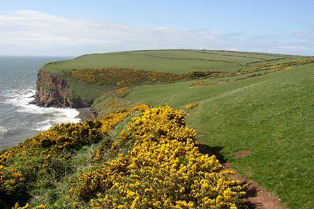
This excellent Cumbria walk follows the path north along the coast from St Bees to Whitehaven. The route includes many features of interest including the monument at the start of the Coast to Coast walk, the seaside resort of St Bees, a lighthouse, the highest cliffs in Cumbria and the interesting heritage associated with the port of Whitehaven. It is a linear walk and uses the train or bus to return to the start.
St Bees station has a small car park (grid ref. NX970119) with alternative parking near the seafront. Exit the car park and turn left over the level crossing. Take the first road on the left, Station Road and follow this for 500 metres, to join Beach Road which is followed to where it bends to the right with the beach front car parks ahead and to your left. Turn left off the car park and follow the pavement to reach the monument marking the start of the Coast to Coast path (grid ref. NX961117). Continue to the beachfront and turn right (with the sea to your left), cross the lifeboat ramp and soon after reach a footbridge. Cross this and continue on the stepped path straight ahead that rises quite steeply onto the headland.
The path follows the top of the cliffs heading west and continues to rise although the gradient has eased. Reaching a gate (grid ref. NX953118), the path bears right heading almost northerly across the flank of South Head and still keeping to the cliff tops. The path continues without any navigational problems for 1.4 kilometres to Fleswick Bay. Here the path bends to the right, descends into a shallow valley and after crossing the stream (grid ref. NX945135), bends sharp left up steps to re-join the clifftops.
Stay on the clear path ahead passing two RSPB observation platforms on your left to pass St Bees Lighthouse, which on your right (grid ref. NX940143). Head to the right of a white building and continue north on a less worn path. At this point the cliffs rise over 300 feet above the sea. The onward path turns sharp right and shortly after swings left to reach a gate where you head bear right and follow the uphill path with a fence on your right. You descend a short flight of steps, go over a small footbridge and pass a bench. Continue through field to pass to the left of a small quarry (grid ref. NX954153) soon reaching a track, which leads from the quarry.
After a few metres bear left off the track (by a wall) and head northeast. Uphill on your right is a trig point which marks the highest point on the walk. Continue to reach a wooden marker post (grid ref. NX961159). Turn sharp left and then follow the path round to the right. You pass the remains of an old mine on your left. The next objective is the "Candlestick Chimney" which can be seen ahead.
Turn right at the Chimney and follow a wide path to reach a small parking area. Just to the left of this is a semi-circular viewing platform which offers an interesting perspective of Whitehaven harbour. Follow the path from this viewing area and continue don steps into the harbour area. Bear right and follow the quayside past the marinas (on your left) to reach North Shore Road (with a contemporary metal sculpture on your left). Cross the road and walk through the car park opposite to reach Whitehaven station and the end of the walk.
Other walks nearby
| Walk 1745 | Grike and Caw Fell from Kinniside Stone Circle | mod/hard | 13.5 miles |
| Walk 1671 | Grike & Crag Fell | easy/mod | 6.6 miles |
| Walk 2058 | Ennerdale Skyline incl. Steeple & other fells | mod/hard | 13.8 miles |
| Walk 3667 | Ennerdale Water Circular | moderate | 7.1 miles |
| Walk 1082 | Ennerdale Horseshoe | severe | 18.0 miles |
| Walk 1303 | Buckbarrow, Seatallan & Middle Fell from Loweswater | moderate | 7.0 miles |
| Walk 3489 | Scale Bridge & Low Wood from Greendale | easy | 5.2 miles |
| Walk 1302 | Low Fell and Fellbarrow from Loweswater | easy/mod | 6.0 miles |
| Walk 3485 | High Birkhow & Low Wood from Wast Water | easy | 4.2 miles |
| Walk 3676 | Hen Comb from Loweswater | moderate | 5.4 miles |
Recommended Books & eBooks
Walking the Lake District Fells - Buttermere
 Part of the Walking the Lake District Fells series, this guidebook covers a wide range of routes to 32 Lakeland summits that can be climbed from the Buttermere, Lorton and Newlands valleys, with highlights including Haystacks, High Stile, Grasmoor and the fells of the Coledale Round. Suggestions for longer ridge routes are also included.
More information
Walking the Lake District Fells - Langdale
 Part of the Walking the Lake District Fells series, this guidebook covers a wide range of routes to 25 Lakeland summits that can be climbed from the Great Langdale valley, Ambleside and Grasmere, with highlights including Scafell Pike, Bowfell, the Langdale Pikes and Helm Crag (the Lion and the Lamb). Includes suggestions for longer ridge routes.
More information
Messaging & Social Media
Message Walking Britain and follow the latest news.

Mountain Weather
Stay safe on the mountains with detailed weather forecasts - for iOS devices or for Android devices.