Walk 3563 - printer friendly version
Fan Brycheiniog and Picws Du Walk
Author - Lou Johnson
Length - 7.1 miles / 11.5 km
Ascent - 2000 feet / 606 metres
Grade - moderate
Start - OS grid reference SN853218
Lat 51.8829260 + Long -3.6678499
Postcode LD3 8YS (approx. location only)
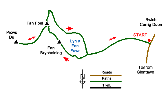
This Brecon Beacons walk includes the summits of Fan Brycheiniog and Picws Du together with the minor top of Fan Foel. The route also includes Llyn y Fan Fawr and a view down to Llyn y Fan Fach. The walk generally follows well used paths although a good sense of direction and map reading skills are required in poor visibility.
The start is a small parking area on the west side of the road about a kilometre before reaching the highest point of Bwlch Cerrig Duon (grid ref.SN853218). The best approach is from the A4067 in the Swansea Valley. Heading north from Glyntawe take the minor road on the left signed to Trecastle and follow this road for 5 kilometres (3 miles). The parking area has a wooden post which makes identification easier.
After parking take the clear path which initially heads northwest before soon swinging west-northwest to cross the infant River Tawe (grid ref. SN846219). The generally clear rising path continues west-southwest for just over a kilometre to reach the outflow from Llyn y Fan Fawr. Continue along the path heading west up the escarpment. This soon steepens and climbs the eastern flank of Fan Brycheiniog to reach the edge of the escarpment (grid ref. SN829213) at Bwlch Giedd. Turn right along the edge following the Beacons Way and you soon reach the trig point on Fan Brycheiniog (802 metres).
After taking in the view, continue north passing a cairn on Twr y Fan Foel (grid ref. SN824221). Continue along the path to reach a further cairn after 500 metres on the rounded minor summit of Fan Foel. Turn sharp left and follow the edge path for 1.4 kilometres to reach the lofty summit of Picws Du (749 metres) where you have a grandstand view down to Llyn y Fan Fach some 500 feet below.
Retrace your steps to the cairn on Fan Foel (grid ref. SN821223). Turn north here and descend steeply down the escarpment for 500 metres to a path junction (grid ref. SN822228). Turn sharp right and follow the path south along the foot of the escarpment to reach the northern shore of Llyn y Fan Fawr after 1.6 kilometres. The path continues along the eastern shore of the lake (lake to your right) to reach the outflow passed earlier in the walk. Turn left and retrace your steps back to the start.
Messaging & Social Media
Message Walking Britain and follow the latest news.

Mountain Weather
Stay safe on the mountains with detailed weather forecasts - for iOS devices or for Android devices.