Swaffham Prior & Devil's Dyke from Reach
Cambridgeshire Walk
County/Area - Cambridgeshire
Author - Lou Johnson
Length - 6.6 miles / 10.7 km Ascent - 200 feet / 61 metres
Time - 3 hours 30 minutes Grade - easy/mod
Maps 

| Ordnance Survey Explorer 226 | Sheet Map | 1:25k | BUY |
| Anquet OS Explorer 226 | Digital Map | 1:25k | BUY |
| Ordnance Survey Landranger 154 | Sheet Map | 1:50k | BUY |
| Anquet OS Landranger 154 | Digital Map | 1:50k | BUY |
Walk Route Description
Click image to see photo description.
This Cambridgeshire walk starts from the village of Reach and crosses the fens to Swaffham Prior. This village has much to offer with some interesting churches a restored operational windmill and a variety of places to stop for refreshments. The return route follows the Devil's Dyke or Ditch, a 6th century defensive structure that rises to about 8 metres high.
The start is the small car park at the junction of Fair Green and Burwell Road in Reach (grid ref. TL568661). This car park is located at the north-western end of the Devil's Dyke which is followed on the return leg of the walk. Exit the car park onto Fair Green and walk (with the green on your left) past houses on your right. Reaching Chapel Lane (a cul-de-sac), bear round to the left staying on Fair Green to soon reach and walk straight ahead to a T-junction. Turn right and walk straight ahead into another cul-de-sac (The Hyde). Ignore all side streets and join a concrete path. Cross a footbridge on your left and once across the stream turn left and follow a clear track for 800 metres to reach a lane (grid ref. TL561658).
Turn left, re-cross, the stream on a bridge and turn right along the Public Byway (Barston Drove). Follow this track for 1.6 kilometres to reach Swaffham Road (grid ref. TL572648). Turn right into Swaffham Prior. Continue straight ahead past Rogers Road (on your left) and into Lower End. Just before the next road junction on the left (The Beeches), turn left along a signed footpath. This soon turns right and brings you onto Fairview Grove.
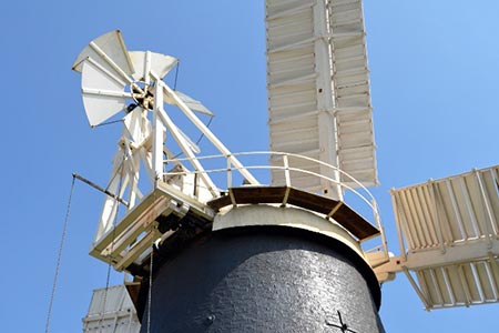
Follow Fairview Grove for 200 metres to a T-junction. Turn right onto Mill Hill. You will see the windmill on your right. Worth a visit, this restored windmill is now operational and is open to the public on Thursday morning and the second Sunday of the month. (Please check their website before visiting.) The GPS route for this walk allows you to explore the village. However, you can also devise your own route around this interesting village. Two interesting churches (St Mary's and SS Cyriac & Julitta's Church), a variety of places to eat and an attractive High Street make this a great place for lunch.
After completing your exploration, locate Cage Street at the northern end of the High Street. Follow this street to the junction with the B1102. Go straight across into Heath Road. Just after an access road on your left, take the signed footpath up a flight of steps. Follow this path across fields for just over two kilometres to reach the Devil's Dyke (grid ref. TL591638). Turn left onto the path beside the Dyke. After 1.6 kilometres you reach Burwell Road. Go straight across and continue following the Devil's Dyke for a further two kilometres back to the car park used at the start of the walk.
Other walks nearby
| Walk 2352 | Lode Mill, Quy Water & Quy Fen | easy | 4.2 miles |
| Walk 2476 | Moulton & Gazeley Circular | easy | 6.7 miles |
| Walk 3721 | Oakington and Longstanton round via Rampton Drift | easy | 6.0 miles |
| Walk 2242 | Cavenham Heath and Lark Valley from Mildenhall | easy/mod | 7.8 miles |
| Walk 1963 | Elsworth & Conington | moderate | 10.1 miles |
| Walk 3444 | Fen Drayton Nature Reserve Walk | easy | 4.6 miles |
| Walk 2243 | Mare Way & Wimpole Estate from Orwell | easy | 5.2 miles |
| Walk 3741 | St. Ives, Houghton & the Hemingfords | easy | 5.6 miles |
| Walk 3103 | Wimpole Park and Whaddon | easy/mod | 8.3 miles |
| Walk 3263 | Clare and Cavendish Circular | easy/mod | 7.7 miles |
Recommended Books & eBooks
No suggestions for this area.Messaging & Social Media
Message Walking Britain and follow the latest news.

Mountain Weather
Stay safe on the mountains with detailed weather forecasts - for iOS devices or for Android devices.