Firle Beacon & Cuckmere Valley
South Downs Walk
Nat Park - South Downs
County/Area - East Sussex
Author - Lou Johnson
Length - 10.4 miles / 16.9 km Ascent - 1100 feet / 333 metres
Time - 6 hours 20 minutes Grade - moderate
Maps 

| Ordnance Survey Explorer OL24 | Sheet Map | 1:25k | BUY |
| Anquet OS Explorer OL24 | Digital Map | 1:25k | BUY |
| Ordnance Survey Landranger 199 | Sheet Map | 1:50k | BUY |
| Anquet OS Landranger 199 | Digital Map | 1:50k | BUY |
Walk Route Description
Click image to see photo description.
This South Downs walk in East Sussex starts from the village of Alfriston in the Cuckmere Valley and follows the South Downs Way west to cross Bostal Hill and onto Firle Beacon. The return route follows a different route through Blackstone Bottom to reach the High and Over White Horse. From this great viewpoint the route drops down to follow the Cuckmere River back to the start.
The start is the Willows long stay car park on the north side of Alfriston (grid ref. TQ521033). After parking exit on to North Street and turn left. Follow this road into the village centre. Turn right into Star Lane (by the Star Inn and George Inn). You are now on the South Downs way which is well waymarked. Continue up Star Lane and go straight across at the road junction into Kings Ride. Keep straight ahead initially past houses to the end of the road. Keep straight ahead and join a track which continues to steadily gain height. The track curves to the right and passes woodland on the left. Reaching a junction, go straight ahead.
Continue along the South Downs Way to reach Bostal Hill (grid ref. TQ497048) from where there is an excellent view northeast. The South Downs Way descends slight to pass Bo Peep car park before climbing again to reach the trig point on Firle Beacon. This is the highest point on the route and an ideal place to take a break and enjoy the view.
Retrace your steps back towards the Bo Peep car park. Just before the car park turn right, taking the bridleway signed to High and Over. The clear track (with field boundary on your left) swings round to a southerly direction and descends gently for just over three kilometres to reach a cross track (grid ref. TQ489024). Fork left here and pass the small reservoir which should be on your immediate left. Continue along the track (The camp on OS maps) past the trig point on Camp Hill (on your right).
A short way beyond the trig point, at the next fork go left through a gate and follow the path alongside the edge of woodland on your left. Do not go through the next bridle gate, instead keep close to the fence on your left to reach Alfriston Road (grid ref. TQ510013). Cross the stile and turn right. There is a grass verge which is safer than walking on the road.
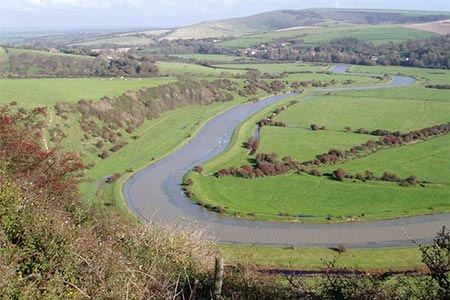
Turn left into the High and Over car park. Walk to the left of an information board. Go through the trees and continue along the path that leads to the viewpoint. Using the topograph you can identify local landmarks. Note you cannot see the White Horse from here! Over three hundred feet below lies the Cuckmere River which follows an intricate meandering course to the sea. On the hillside below is the white horse which was first cut in 1836. In 1924 the horse was recut.
Continue down the path across steep grassy slopes. For some of the way there are steps cut into the hillside. Continue downhill and at the bottom bear right to reach the riverbank. Turn left and continue upstream with the river on your right. You now have an easy walk following the riverside path for about four kilometres back to Alfriston.
Other walks nearby
| Walk 3120 | Alfriston to Rodmell by the South Downs Way | moderate | 9.0 miles |
| Walk 3575 | High and Over White Horse | easy | 2.0 miles |
| Walk 1357 | The Seven Sisters from Exceat | moderate | 14.0 miles |
| Walk 1633 | Charleston Farm & Firle Beacon | easy/mod | 4.6 miles |
| Walk 1015 | Ouse Valley & Beddingham Hill | moderate | 12.0 miles |
| Walk 2227 | East Dean Circular | moderate | 11.0 miles |
| Walk 1638 | Beachy Head & Eastbourne | easy/mod | 6.2 miles |
| Walk 2419 | Southease, Ditchling Beacon & Lewes | mod/hard | 17.0 miles |
| Walk 1038 | Firle Beacon | moderate | 13.3 miles |
| Walk 3516 | Eastbourne to Alfriston by the South Downs Way | mod/hard | 12.5 miles |
Recommended Books & eBooks
The South Downs Way
 Guidebook to walking the South Downs Way National Trail, a 100 mile (160km) route between Winchester and Eastbourne through the South Downs National Park, described in both directions over 12 stages. Easy walking on ancient and historical tracks, taking in wooded areas, delightful river valleys and pretty villages. With 1:25K OS map booklet.
More information
Walks in the South Downs National Park
 Guidebook with 40 circular walks throughout the South Downs National Park, exploring the beautiful chalk hills between Eastbourne and Winchester. The walks range from under 5 miles to 11 miles, including Beachy Head and the Seven Sisters, Ditchling Beacon and hundreds of prehistoric sites. Accessible all year, but wild flowers best in spring.
More information
Messaging & Social Media
Message Walking Britain and follow the latest news.

Mountain Weather
Stay safe on the mountains with detailed weather forecasts - for iOS devices or for Android devices.