Walk 3576 - printer friendly version
River Tweed & Dryburgh Abbey Walk
Author - Lou Johnson
Length - 5.5 miles / 8.9 km
Ascent - 600 feet / 182 metres
Grade - easy
Start - OS grid reference NT593318
Lat 55.5781440 + Long -2.6471109
Postcode TD6 0RQ (approx. location only)
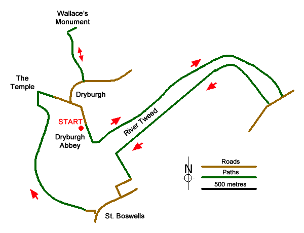
This leisurely Scottish Borders walk starts from Dryburgh Abbey and follows the River Tweed downstream before crossing to the other side to pass through St Boswells. The route continues upstream and visits Wallace's Stature before returning to the start.
The start is the car park for Historic Scotland's Dryburgh Abbey where an admission charge is payable (grid ref. NT593318). Exit the car park the track to the right signed Borders Abbey Way passing toilets on your left. In 100 metres turn left over a stile and join the path with the River Tweed on your left. When the river bends to the right, the onward route follows a track climbing across the steep wooded riverbank. Co9ntinue into a field following path with field boundary on your immediate right with a mill below on your right. Reaching a junction, turn right to Mertoun Bridge soon descending steps to reach a road (grid ref. NT611321).
Turn right and cross the River Tweed. Just over the bridge take a flight of steps down on the right to join the St Cuthbert's Way. Continue on the path upstream with river on your right. Walk past a weir and after 1.5 kilometres pass a golf course on your left. Turn left along a surfaced track past the clubhouse to reach a lane. Two hundred and fifty metres past the clubhouse, turn right into Braeheads Road. You pass a fine stone-built house on the left complete with a turret. Continue with the high wall on your left and take the next lane on the left (also Braeheads Road).
Follow this lane to reach Main Street (B6404). Turn right and continue to pass public toilets on the left side of the road. Turn right along Hamilton Pace (following the St Cuthbert's Way sign on the lamp post). Turn right at another SCW sign, to fork left down a path just after a lamp post. Go left again down a flight of steps to reach the riverside path. Follow the path for just under a kilometre to reach a suspension foot bridge (grid ref. NT558320). Cross the bridge and pass the Temple of Muses on Bass Hill (on your left0> Follow the path around to the right and follow the lane for 300 metres to a road junction.
Turn left and just after the road swings right (by Newmains), take the path on the left. This leads up to Wallace's Statue. Retrace your steps down the path to the road, turn right and continue back to the junction passed a short while ago. Follow the road around to the left past the hotel entrance and return to the car park.
Messaging & Social Media
Message Walking Britain and follow the latest news.

Mountain Weather
Stay safe on the mountains with detailed weather forecasts - for iOS devices or for Android devices.