Gragareth from Ireby Walk
Walk 3584 - Route Maps & Profile
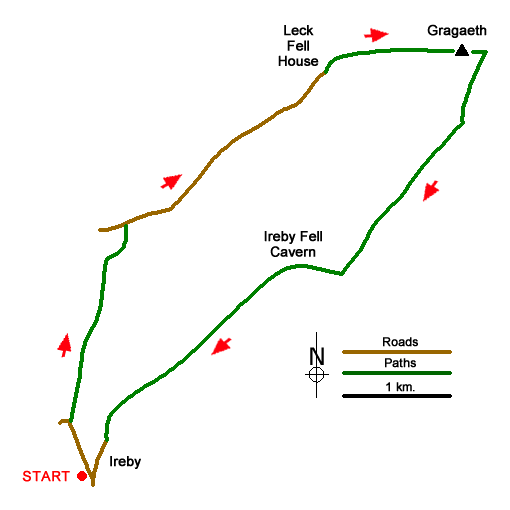
Route Map
Digital Maps - Copyright © 2011-2024. All rights reserved.
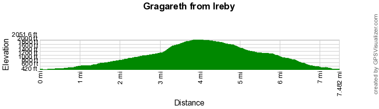
Route Profile
Sketch Map
Suggested Maps 

| Ordnance Survey Explorer OL2 | Sheet Map | 1:25k | BUY |
| Anquet OS Explorer OL2 | Digital Map | 1:25k | BUY |
| Ordnance Survey Landranger 97 | Sheet Map | 1:50k | BUY |
| Anquet OS Landranger 97 | Digital Map | 1:50k | BUY |
It is recommended you take a map. The preferred scale is 1:25k.
Start Point Details
Ordnance Survey Grid Ref SD654755
Latitude 54.174114 Longitude -2.531543
Postcode LA6 2JY
what3words start measure.strutted.recoup
Walk description may contain detailed information on the start point for this walk.
Further Information
Yorkshire Dales
Walking in the Yorkshire Dales National Park covers an extensive area, which contains a wide variety of scenic interest. Each Dale is usually named after its river although there are a few examples that don't follow this rule. The varied underlying geology is reflected in the scenery with limestone and gritstone the prominent rocks resulting in virtually every type of scenery from dry valleys to wild moorland. Yorkshire Dales Walking Guide
Lancashire
Lancashire offers many walking opportunities with a number of areas of high ground. The highest point is Gragareth (near Whernside) at 627 metres. The rivers drain west from the Pennines. The coast is backed by a coastal plain. Excellent areas for walking include Arnside and Silverdale National Landscape, Beacon Fell Country Park and the Forest of Bowland AONB, which includes Pendle Hill. Further south are the West Pennine Moors and the Forest of Rossendale.
Walk grading - Learn how each walk is assessed and select a walk to suit your ability and experience by going to Walk Grading Details.
Messaging & Social Media
Message Walking Britain and follow the latest news.

Mountain Weather
Stay safe on the mountains with detailed weather forecasts - for iOS devices or for Android devices.