Skelton Tower & Hole of Horcum from Levisham
North York Moors Walk
Nat Park - North York Moors - North York Moors East
County/Area - North Yorkshire
Author - Lou Johnson
Length - 7.4 miles / 12 km Ascent - 900 feet / 273 metres
Time - 4 hours 40 minutes Grade - easy/mod
Maps 

| Ordnance Survey Explorer OL27 | Sheet Map | 1:25k | BUY |
| Anquet OS Explorer OL27 | Digital Map | 1:25k | BUY |
| Ordnance Survey Landranger 94 | Sheet Map | 1:50k | BUY |
| Anquet OS Landranger 94 | Digital Map | 1:50k | BUY |
Walk Route Description
Click image to see photo description.
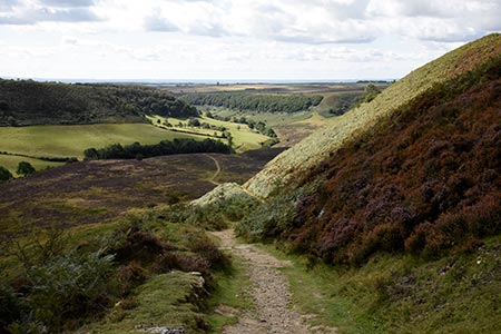
This North York Moors walk starts from the village of Levisham which lies just over a mile to the west of the A169 Scarborough to Whitby road. The route is full of interest including Skelton Tower, Levisham Moor and the deep valley of the Hole of Horcum. The route follows good paths for much of the route and provides an excellent introduction to walking in this area.
The start is the village of Levisham (grid ref. SE831906) where on-street parking is usually available. After parking walk north through the village and keeping to the left of the Horseshoe Inn continue along Braygate Lane for 600 metres to where the tarmac lane bends sharp left (grid ref. SE830910). At this point leave the lane and continue straight ahead on an enclosed track (marked as Braygate Lane on OS maps).
Reaching a gate (grid ref. SE827916) you enter open moorland. Keep straight ahead keeping the wall to your left. After 500 metres the wall turns sharp left. Again, keep straight ahead following a clear path. The path heads uphill and then descends before trending to the right to lead you to Skelton Tower (grid ref. SE820929). The tower offers a great vantage point for watching steam trains on the North York Moors Railway which lies in a wooded valley below.
From the tower, turn east following a clear track along the edge of the valley to your left. After running parallel to the valley for about a kilometre, the track crosses open moorland Just over three kilometres from Shelton Tower, the track bears right, crosses a stream and climbs up to reach the A169 at Saltergate (grid ref. SE849941). You now have a good view down into the Hole of Horcum.
Go left through a gate and then right to follow the descending path into the Hole of Horcum. You soon pass to the right of the buildings at Low Horcum (grid ref. SE844932). Soon after the path forks. Bear left here and follow the path running parallel to the valley on your right. The path forks again. Ignore the rising path to the right and keep straight ahead to a gate. Continue through the gate and follow a section of boardwalk to reach a footbridge over a stream. You soon cross another stream and reach a path junction (grid ref. SE838918).
Ignore the path on the right and follow the path to Levisham. The path climbs gently and then enters woodland. The path bends right and heads west. Ignore the paths to Lockton and continue to reach a road (grid ref. SE833903). Turn right and you are soon back in the village of Levisham.
Other walks nearby
| Walk 1397 | Hole of Horcum from Levisham Station | easy/mod | 8.5 miles |
| Walk 1396 | Hole of Horcum and Saltergate Brow from Lockton | moderate | 10.3 miles |
| Walk 1867 | Hole of Horcum & Bridestones from Lockton | moderate | 9.8 miles |
| Walk 3534 | Dundale Pond & Hole of Horcum from Saltergate | easy/mod | 5.2 miles |
| Walk 1602 | Saltergate, Fylingdales & Allerston High Moor | moderate | 11.5 miles |
| Walk 2665 | Cawthorne Roman Camp Circular | moderate | 12.2 miles |
| Walk 1930 | Wheeldale Moor circular | moderate | 11.3 miles |
| Walk 1922 | Goathland & Howl Moors | moderate | 11.2 miles |
| Walk 2325 | Troutsdale Circular | moderate | 10.1 miles |
| Walk 2563 | Egton Bridge & Grosmont from Goathland | moderate | 12.5 miles |
Recommended Books & eBooks
Trail and Fell Running in the Yorkshire Dales
 Guidebook to 40 of the best trail and fell runs in the Yorkshire Dales National Park. Ranging from 5 to 24 miles, the graded runs start from bases such as Ribblehead, Dent, Sedbergh, Malham and Grassington and take in the region's diverse delights, from castles and waterfalls to iconic mountains such as Whernside, Ingleborough and Pen Y Ghent.
More information
Messaging & Social Media
Message Walking Britain and follow the latest news.

Mountain Weather
Stay safe on the mountains with detailed weather forecasts - for iOS devices or for Android devices.