Rainow Circular
Peak District Walk
Nat Park - Peak District - Shutlingsloe Macclesfield Forest
County/Area - Cheshire
Author - Lou Johnson
Length - 5.5 miles / 8.9 km Ascent - 850 feet / 258 metres
Time - 3 hours 40 minutes Grade - easy/mod
Maps 

| Ordnance Survey Explorer OL24 | Sheet Map | 1:25k | BUY |
| Anquet OS Explorer OL24 | Digital Map | 1:25k | BUY |
| Ordnance Survey Landranger 118 | Sheet Map | 1:50k | BUY |
| Anquet OS Landranger 118 | Digital Map | 1:50k | BUY |
Walk Route Description
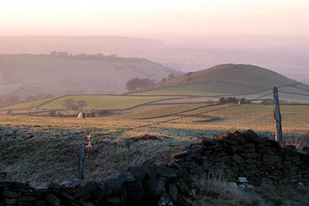
Click image to see photo description.
This Cheshire walk from Rainow explores a less-visited part of the Peak District National Park. The terrain is interesting and views good offering an excellent reward for your effort. As with many quieter areas some paths see few walkers so are less easy to follow and with poorer waymarking navigation in places needs care. However, equipped with the relevant OS map you should soon overcome any problems.
The start is the attractive village of Rainow which lies just outside the National Park boundaries. On street parking is generally easy to find, though please think about residents and their access. I parked on Round Meadow opposite the Parish Church (grid ref. SJ951760. After parking return to the B5470 and walk north (with the church to your right). Just after a row of terraced houses on the right fork left into Stocks Lane and follow this north into Smithy Lane. Continue north along this lane which soon becomes Kiskhill Lane at grid ref. SJ953766.
Follow Kiskhill Lane continuing until the tarmac ends. Continue straight ahead on the unsurfaced track for 200 metres to reach a T-junction. Turn right here onto Jumper Lane which is followed to reach a lane at Billinge Head Farm. Turn left along the lane and almost immediately right onto a signed footpath which follows a track in a northerly direction. Keep right where the track forks and continue to reach a stone building on the left (grid ref. SJ959779). Turn right here, cross the stile onto a footpath signed to Harrop Fold. There is little evidence this path is used by many walkers. However, maintain an easterly direction across three fields to enter another field with Harrop Fold Farm in view ahead. The path goes to the right of a barn and waymarks indicate the route ahead.
Just as you join the farm access road, turn right off it and with the field boundary on your right continue south. Cross the access track to New Hey Farm and maintain the same direction south to the left-hand corner of the field keeping the hedge on your immediate left. The path continues in the next field following a wall on your right. Cross the access track to Withinlow Farm, maintain direction following the wall. The path leads to the B5470 (grid ref. SJ963773). Bear right along the road and continue straight ahead across two road junctions.
Just over the brow of the hill take the first signed footpath on the left (grid ref. SJ961769). Walk half right across the first field and reaching a wall, cross the stile and head half right across the next. The path maintains direction across a smaller field and leads to the access track for Wimberry Moss Farm. Follow this track to Smith Lane and turn left. A short way along Smith Lane take the first signed footpath on the right. A short way along the path you reach a path junction. Turn left and head along the path with some farm buildings in the field on your right. The path then crosses a stile on the right and heads to the left of a farm. Entering the next field, gear half right and continue to reach a stile at a wall junction (grid ref. SJ965761).
Go straight ahead, ignoring the cross path. Walk south with the wall on your right and pass a ruined barn on your left. Pass to the left of the farm and follow the track with the wall on your right. The wall soon crosses to your left. The track follows the wall and swings to the right past a small wood on your left and then turns sharp left alongside the perimeter of a 'factory' which is on your right to reach a clear track (grid ref. SJ968755).
Turn right along the track (Lamaload Road or Berristal Road depending which map you are using). The track climbs steadily to reach Snipe House where you continue straight ahead. Pass Higherlane Farm on your left and continue to follow the clear track which soon turns northwest and leads to the B5470 (grid ref. SJ948758). Turn right, and with care, follow this road back to the centre of Rainow.
Other walks nearby
| Walk 2605 | White Nancy & Saddle of Kerridge Nr Bollington | easy | 4.5 miles |
| Walk 1233 | Shining Tor & Windgather Rocks | moderate | 7.5 miles |
| Walk 2527 | Kettleshulme & Taxal Edge from Lamaload | moderate | 10.0 miles |
| Walk 2528 | Kettleshulme & Sponds Hill | moderate | 8.0 miles |
| Walk 2506 | Tegg's Nose from Trentabank | moderate | 7.5 miles |
| Walk 2535 | Wildboarclough & Shutlingsloe from Trentabank | moderate | 7.0 miles |
| Walk 1461 | Shutlingsloe from Trentabank | easy/mod | 3.0 miles |
| Walk 1502 | Shutlingsloe and Macclesfield Forest from Trentabank | moderate | 9.0 miles |
| Walk 1371 | Rossendale Ramble from Sutton | moderate | 12.0 miles |
| Walk 2576 | Fernilee Reservoir, Goyt Valley | easy | 6.0 miles |
Recommended Books & eBooks
Walking in the Peak District - White Peak East
 Guidebook describing 42 half-day and day walks in the limestone landscapes of Derbyshire's White Peak, part of the Peak District National Park. One of two volumes, this book covers the east of the region, with potential bases including Bakewell, Eyam, Castleton, Birchover, Matlock and Wirksworth.
More information
Dark Peak Walks
 Guidebook to 40 walks in the Dark Peak area of the Peak District National Park. 35 circular routes for most abilities, from 8km to 19km, around Edale, Marsden, Fairholmes, Baslow and Castleton, including Kinder Scout and Mam Tor, and 5 longer (25km to 45km) routes highlighting the best of the Gritstone Edges, High Moorland and Deep Valleys.
More information
Messaging & Social Media
Message Walking Britain and follow the latest news.

Mountain Weather
Stay safe on the mountains with detailed weather forecasts - for iOS devices or for Android devices.