Walk 3593 - printer friendly version
Meldon Hill from Cow Green Reservoir Walk
Author - Lou Johnson
Length - 9.2 miles / 15 km
Ascent - 1300 feet / 394 metres
Grade - moderate
Start - OS grid reference NY810309
Lat 54.6728060 + Long -2.2961385
Postcode DL12 0HX (approx. location only)
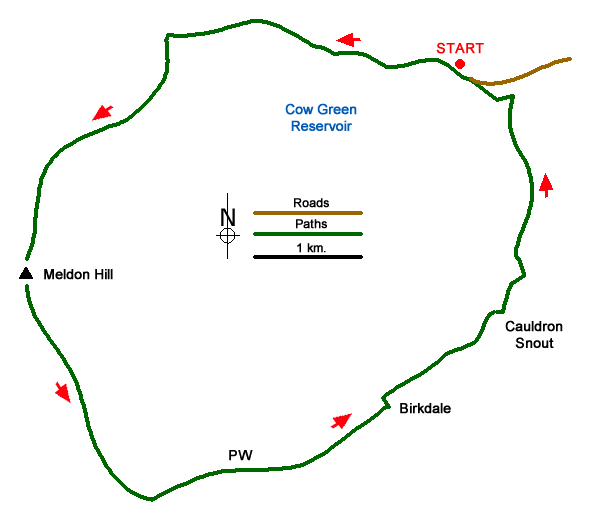
This North Pennine walk starts from Cow Green Reservoir and follows a counter clockwise route initially visiting the summit of Meldon Hill. The return route descends to the Pennine Way (with an option extension to nearby High Cup Nick) and continues via Cauldron Snout waterfall back to the start. The route crosses remote terrain with few if any clear paths. Therefore, this walk is for experienced hillwalkers only! A good sense of direction is required together with the relevant OS 25k map. A GPS device would also be useful.
The start is the car park overlooking Cow Green Reservoir (grid ref. NY810309) which can be reached from the B6277 in Teesdale. After parking familiarise yourself with the terrain on Meldon Hill which rises on the other side of the reservoir. There are several paths that lead down to the reservoir shore. Take one of these and head WNW following the shore. When I walked this route the water level in the reservoir was low and I walked along the shore. You reach a small peninsula (grid ref. NY795313) and the best route is to take the shortest route keeping well north of the 503 spot height. There is some soft ground, but this can generally be avoided.
Continue along the shore to reach the point where the River Tees empties into the reservoir. The river needs to be crossed. I found some convenient stones about 100 metres up the river and managed to cross with dry feet. When the river is in spate crossing may not be possible.
Once safely across the river head roughly south keeping to the left of the small hill (spot height 534) to locate Mattergill Sike. I followed trods on the north side continuing upstream to grid ref. NY774301. From here I headed south climbing the northern flank of Meldon Hill. Do be careful as there are shake holes some of which are not marked on OS maps. The route steepens as you gain height. Reaching the summit plateau there is a cairn to the east which offers a good view down to Cow Green Reservoir and a derelict OS trig column.
Leaving the summit, head south for 400 metres and then descend roughly parallel with Watersinking Sike for a similar distance before making a beeline for the Pennine Way which was reached at grid ref. NY783270. (Here you have the option of turning west and following the Pennine Way to High Cup Nick. This option is well worth the effort if you have the time and energy and adds 8 kilometres to the walk.) For those returning directly to Cow Green, turn left along the Pennine Way and follow the well walked path to Birkdale and Cauldron Snout. Once across the River Tees turn left leaving the Pennine Way and head back to the start.
Messaging & Social Media
Message Walking Britain and follow the latest news.

Mountain Weather
Stay safe on the mountains with detailed weather forecasts - for iOS devices or for Android devices.