Walk 3608 - printer friendly version
Martham Ferry & River Thurne from West Somerton Walk
Author - Lou Johnson
Length - 4.0 miles / 6.5 km
Ascent - 100 feet / 30 metres
Grade - easy
Start - OS grid reference TG468200
Lat 52.7213040 + Long 1.6531507
Postcode NR29 4EB (approx. location only)
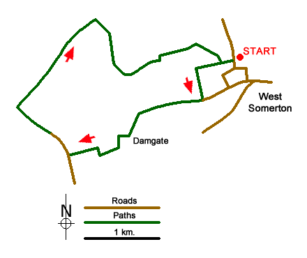
A Norfolk walk from the village of West Somerton and can be extended by combining with walk 3609 to provide a longer walk. The route explores the countryside west of the village before reaching the River Thurne. A path along the river leads you back to the start passing West Somerton Drainage Mill along the way.
The walk starts from the small gravel parking area at Somerton Parish Staithe (grid ref. TG468200) where there is a pleasant grassed area and seat adjacent to the moorings. Exit the car park and turn right into Horsey Road. Turn first right into Staithe Road. Follow Staithe Road to the left where the road forks. Reaching a farm, bear left onto footpath, pass a derelict 'shed' and head through a narrow gap. Reaching Sandy Lane (grid ref. TG464198), turn left for 300 yards with open fields on your right. At the fingerpost, turn right and follow the path between fields. The path turns left, right, right and then left again and continues to reach houses.
Take the first right, then the first left and continue to reach Morgrove Lane. Turn right into this lane. After just under 200 yards heads left behind a hedgerow, follows the field edge. Passes through some trees to join a lane (grid ref. TG454190). Turn left and walk to Ferrygate Lane. Turn right here and walk north until you reach a mooring with boats before Martham Ferry. Bear right here off the road and with the water on your left follow the path/track alongside the water to reach the River Thurne (grid ref. TG445194). With the river on your left, continue along the riverside path. After just under a mile the path bends right and Martham Broad opens out on your left. Nearing West Somerton, you get a fine view of West Somerton Drainage Mill on the far bank of the river. Continue along the path to reach some moored boats and farm buildings to reach Staithe Road. Turn left and continue to Horsey Road. Turn left again and the car park used at the start is a short way along on your left.
Messaging & Social Media
Message Walking Britain and follow the latest news.

Mountain Weather
Stay safe on the mountains with detailed weather forecasts - for iOS devices or for Android devices.