Ettrick Hills Horseshoe
Scottish Borders Walk
County/Area - Scottish Borders & Dumfries and Galloway
Author - Lou Johnson
Length - 8.0 miles / 13 km Ascent - 1700 feet / 515 metres
Time - 5 hours 40 minutes Grade - mod/hard
Maps 

| Ordnance Survey Explorer 330 | Sheet Map | 1:25k | BUY |
| Anquet OS Explorer 330 | Digital Map | 1:25k | BUY |
Walk Route Description
Click image to see photo description.
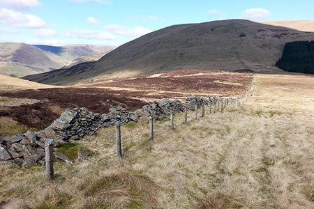
This walk in the Southern Uplands of Scotland explores a wild area of hills lying northeast of Moffat. The route covers several summits including Bodesbeck Law (665 m.), White Shank (662 m.), Smidhope Hill (644 m.) and Capel Fell (678 m.) so you can expect some re-ascents during the walk. The route has sections where paths are feint so a good sense of direction in this complex landscape is essential. However, from Bodesbeck Law to the final decent you do have a stone wall to help with navigation. Despite this the walk should not be completed when low cloud covers the summits. You can also expect to encounter some wet ground during the walk.
The start can be reached along a minor road leaving the B709 at Ettrick. Continue until you reach the end of the tarmac road at a large turning circle (grid ref. NT189093). Go through the gate (signed Ettrick Horseshoe) and walk half right on a clear rising track. Keep straight ahead at the first junction after 400 metres (grid ref. NT186095) and continue climbing. The track continues through the forest and reaches open ground. Go left along the fence to cross a stile by a gate. Follow grassy track uphill onto the flank of Bught Hill. When the track ends bear left and head west along an often soft and indistinct path which leads to a wall. Cross the wall and head to the summit of Bodesbeck Law (grid ref. NT169104). The view from summit is excellent and you can also assess the onward route south.
From Bodesbeck Law head south towards the wall (on your left) and continue alongside it down to a rather wet col. Cross the track and start an ascent again with the wall on your left. The wall bears right and then left to reach the top of Faulside Hill. A short descent to another col with a slightly steeped ascent onto White Shank. Continue following the wall (on your left) over a col to reach Smidhope Hill after a steep ascent. Continue down the narrow ridge keeping the wall on your left. Go through the gate in the col and complete the steep ascent onto Capel Fell. This is the highest summit of the walk and it is worth taking in the view across the wonderful landscape from this vantage point.
Follow the fence down to a gate and follow fence downhill with dramatic Rae Grain on your right. The path descends steeply to a col (grid ref. NT172064) and the Southern Upland Way. Turn left over stile by a gate and head towards the forest. Descend through woods with a stream on your right. You soon join a track (grid ref. NT174067). Turn right and follow the Southern Upland Way. The route leaves the forest with the track running along the edge of forest on your right with Ettrick Water on your left. The track veers left to Over Phawhope. The track bends left and then crosses Ettrick Water soon veering right. Continue to Potburn (grid ref. NT183088). Continue along the Southern Upland Way back to the start.
Other walks nearby
| Walk 2008 | Hart Fell via Saddle Yoke & the Black Hope Horseshoe | mod/hard | 8.5 miles |
| Walk 2006 | Grey Mare's Tail & White Coomb | mod/hard | 7.2 miles |
| Walk 2045 | Capel Fell via Sailfoot Law & Broken Back Hill | moderate | 5.8 miles |
| Walk 2035 | Hart Fell via Hartfell Spa | moderate | 7.2 miles |
| Walk 2280 | Hart Fell & Whitehope Heights | moderate | 8.4 miles |
| Walk 2618 | Broad Law & Megget Stone | moderate | 5.0 miles |
| Walk 2050 | The Crown of Scotland | moderate | 9.0 miles |
| Walk 3759 | St. Mary's Loch Circular | easy/mod | 7.5 miles |
| Walk 2268 | Annandale Way | moderate | 9.0 miles |
| Walk 2135 | Camps Reservoir Circular | easy | 5.8 miles |
Recommended Books & eBooks
The Borders Abbeys Way
 Guidebook to the Borders Abbeys Way, a 68 mile circuit in the Scottish Borders, taking in 4 of Britain's grandest ruined medieval abbeys. Beginning and ending in Tweedbank, the route, which is described over 6 stages, is as rich in history as it is in pastoral charm. Relatively flat, it is suitable for people with a moderate level of fitness.
More information
Walking in the Southern Uplands
 Guidebook to 44 varied day walks and over 100 summits in the Southern Uplands of Scotland, stretching south-west from Edinburgh to the English border, including the Galloway and Pentland Hills. Between 2 and 29km, there is something for all seasons and all abilities in remote and rugged hill country.
More information
Messaging & Social Media
Message Walking Britain and follow the latest news.

Mountain Weather
Stay safe on the mountains with detailed weather forecasts - for iOS devices or for Android devices.