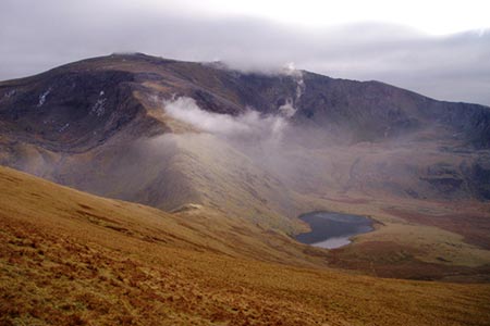
Moel Cynghorion from Llyn Cwellyn
Snowdonia/Eryri Walk
Nat Park - Snowdonia - Snowdon Crib Goch
County/Area - Gwynedd
Author - Lou Johnson
Length - 5.0 miles / 8.1 km Ascent - 1800 feet / 545 metres
Time - 4 hours 20 minutes Grade - moderate
Maps 

| Ordnance Survey Explorer OL17 | Sheet Map | 1:25k | BUY |
| Anquet OS Explorer OL17 | Digital Map | 1:25k | BUY |
| Ordnance Survey Landranger 115 | Sheet Map | 1:50k | BUY |
| Anquet OS Landranger 115 | Digital Map | 1:50k | BUY |
Walk Route Description
Click image to see photo description.
This Snowdonia (Eryri) walk visits the summit of Moel Cynghorion which sees few walkers despite offering excellent views to Snowdon, the Glyders, Anglesey and across the valley to the Nantlle Ridge. The route starts from the car park by Llyn Cwellyn (grid ref. SH564551) which is located just off the A4085 Caernarfon to Beddgelert road at the foot of the Snowdon Ranger Path.
After parking cross the road, take the track opposite up to the station, bear left, cross the railway and join the Snowdon Ranger Path. Continue up to the house. Turn right and pass through the left-hand gate to join the path that zigzags up the hill to reach a gate (grid ref. SH570554). About 300 metres from the gate join a faint path on the left (grid ref. SH573553). This path heads north, trending the right of higher ground, to reach a gate. Go through this gate and, just before the next gate (grid ref. SH572559), turn right to follow a fence uphill.
The grade eases as you make progress and the summit of Moel Cynghorion is reached. There is no trig column and the large stile is probably on the summit. Ignore the stile and turn right along the fence (fence on your left). Cross a stile and continue downhill with the fence still on your left. Below is the reservoir Llyn Fynnon-y-Gwas and this should be used for maintaining the correct direction. Stay with the fence when it bends left. As you near the track below a narrow path leads off to the right down to the track.
Turn right down the Snowdon Ranger Path which is followed downhill soon reaching the point where you left the path on the outward part of the route. Continue down the zigzags back to the start.
Other walks nearby
| Walk 2590 | Nantlle Ridge Walk from Rhyd Ddu (Route A) | moderate | 6.0 miles |
| Walk 2797 | Yr Aran and Snowdon from Rhyd-Ddu | mod/hard | 8.5 miles |
| Walk 3509 | Nantlle Ridge from Rhyd Ddu (Route B) | mod/hard | 8.3 miles |
| Walk 3198 | Snowdon via the South Ridge & Rhyd-ddu Path | mod/hard | 7.5 miles |
| Walk 1951 | Mynydd Mawr from Rhyd-Ddu | moderate | 6.0 miles |
| Walk 2729 | Snowdon by Rhyd-Ddu and Snowdon Ranger Paths | mod/hard | 7.5 miles |
| Walk 1003 | Snowdon by the Llanberis Path | moderate | 9.0 miles |
| Walk 1681 | Moel Eilio & Moel Cynghorion from Llanberis | mod/hard | 10.0 miles |
| Walk 3057 | Moel Eilio from Llanberis | moderate | 7.0 miles |
| Walk 3059 | Moel Cynghorion & Snowdon from near Llanberis | very hard | 13.5 miles |
Recommended Books & eBooks
Snowdonia: 30 Low-level and easy walks - South
 Guidebook describing 30 walks in Snowdonia, Wales. Routes are mostly low level and on clear paths and showcase the region's beautiful scenery and rich history and culture. Part of a 2-volume set, this southern volume includes Trawsfynydd, Bala, Dolgellau, Machynlleth, the Harlech Coast and the valleys of the Mawddach and Dyfi.
More information
The Cambrian Way
 Guidebook to the Cambrian Way, a challenging three-week mountain trek through Wales from Cardiff to Conwy. The 470km un-waymarked route is presented from south to north. Often sticking to long, beautiful ridgelines, it crosses wild and rugged terrain and visits many of Wales's highest mountains, including Snowdon.
More information
Messaging & Social Media
Message Walking Britain and follow the latest news.

Mountain Weather
Stay safe on the mountains with detailed weather forecasts - for iOS devices or for Android devices.