Epworth Circular
Lincolnshire Walk
County/Area - Lincolnshire
Author - Lou Johnson
Length - 6.4 miles / 10.4 km Ascent - 200 feet / 61 metres
Time - 3 hours 20 minutes Grade - easy
Maps 

| Ordnance Survey Explorer 280 | Sheet Map | 1:25k | BUY |
| Anquet OS Explorer 280 | Digital Map | 1:25k | BUY |
| Ordnance Survey Landranger 112 | Sheet Map | 1:50k | BUY |
| Anquet OS Landranger 112 | Digital Map | 1:50k | BUY |
Walk Route Description
Click image to see photo description.
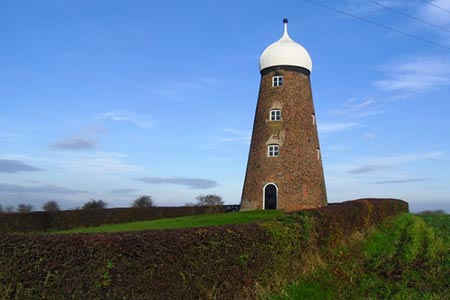
This Lincolnshire walk starts from Epworth and explores the surrounding countryside. The route includes Epworth Turbary Nature Reserve and along the way passes several windmills, some of which have been restored whilst others languish in decay. The start of the walk is the car park at the junction of Church Street and Market Place (grid ref. SE783038).
Exit the car park and walk south along Market Place and turn left into Albion Hill by the Red Lion pub. Reaching the Mowbray Arms on the right, follow the road to the left into Rectory Street. You pass John Wesley's family home on the left which is now a museum. Just past the last bungalow on the right, turn right onto a waymarked track. Continue past an old windmill on the right. 200 metres past the windmill turn right and continue to reach the A161.
Go straight across to a waymarked track opposite. Pass the cemetery on your right and continue along the track. The track bends right and almost immediately left and continues to a T-junction (grid ref. SE775034). Turn left at the way marker and then right to reach a cross track. Go left and then continue under the railway bridge. Follow the path with hedge on your left. Cross a small bridge and then head left of a building. Maintain direction and continue ahead to join an access track. Where the track bends right, leave the track and follow the path alongside Sykers Dyke to reach Turbary Road (grid ref. SE764034). Follow this road for 700 metres to a road junction (grid ref. SE757036).
Turn right along the road and go through gate on the left into Epworth Turbary Nature Reserve. Continue to an information board. Go ahead and continue past a path to a hide on the right. Beyond this the path bears to the right and continues north to a path junction in a clearing in the trees. Turn left here and continue a short way to the access drive for Sandhill Farm (grid ref. SE754042). Turn left and walk past the farm (on your left) to join a track. Continue with the hedge on your right to a T-junction.
Turn right and follow the track (Firth Lane) which, after 800 metres, bears left and continues to West End Road (grid ref. SE769049). Turn left and soon after turn right onto a waymarked track. Continue to a T-junction. Turn right and follow the track with the rear of houses on your right. Turn right at a fingerpost and continue back to the road by an old chapel. Go left along the road. Just past the entrance to C. W Fields, take the signed footpath on the left. At the top turn right and pass a windmill on your left. Continue passing another windmill on your right to Belton Road (grid ref. SE781045).
Turn right and in a few metres take the unsigned path/track on the left to join the Peatlands Way. After 600 metres the track turns right. Continue south to reach a road and track junction. Turn right along the lane. Continue past the graveyard on your left. Shortly after turn right into the churchyard. Go to the left of the church and then continue along Church Walk back to the start (carpark on your right).
Other walks nearby
| Walk 2113 | Haxey, Westwoodside & the Turbary | easy/mod | 7.0 miles |
| Walk 1939 | River Don & New Junction Canal from Fishlake | moderate | 12.6 miles |
| Walk 1293 | Marton & the River Trent circular | easy | 3.0 miles |
| Walk 3566 | Alkborough & Winteringham from Whitton | easy/mod | 9.4 miles |
| Walk 2069 | Brandy Wharf from Atterby Carr Lane | easy | 5.0 miles |
| Walk 3397 | High Melton & Cusworth Hall | moderate | 12.0 miles |
| Walk 1755 | Hooton Pagnell circular | easy/mod | 9.8 miles |
| Walk 3414 | Bishopbridge to Brandy Wharf | easy/mod | 9.0 miles |
| Walk 2141 | Brantingham & Elloughton Dale | easy/mod | 5.7 miles |
| Walk 1414 | Barton and Barrow-on-Humber | easy/mod | 8.3 miles |
Recommended Books & eBooks
No suggestions for this area.Messaging & Social Media
Message Walking Britain and follow the latest news.

Mountain Weather
Stay safe on the mountains with detailed weather forecasts - for iOS devices or for Android devices.