Morcott & Harringworth Circular
Rutland Walk
County/Area - Rutland & Northamptonshire
Author - Lou Johnson
Length - 7.2 miles / 11.7 km Ascent - 450 feet / 136 metres
Time - 4 hours 0 minutes Grade - easy/mod
Maps 

| Ordnance Survey Explorer 234 | Sheet Map | 1:25k | BUY |
| Anquet OS Explorer 234 | Digital Map | 1:25k | BUY |
| Ordnance Survey Landranger 141 | Sheet Map | 1:50k | BUY |
| Anquet OS Landranger 141 | Digital Map | 1:50k | BUY |
Walk Route Description
Click image to see photo description.
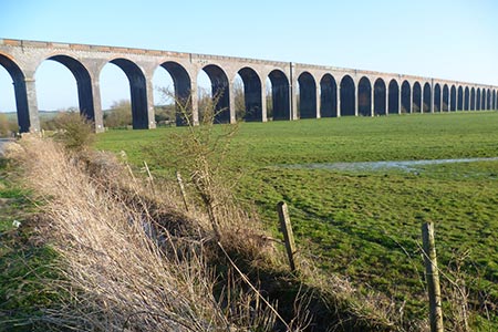
This circular walk from the Rutland village of Morcott follows a section of the Jurassic Way along the Welland Valley to reach Harringworth in Northamptonshire. The route continues beneath the Welland Viaduct to return to the start following the Rutland Round walk. The highlight of the walk is the Welland Viaduct which was built in the 1870's by the Midland Railway. With 82 arches, it is the longest masonry viaduct ion Britain. The walk can be started in Morcott or Harringworth.
Morcott to Harringworth
The start is the centre of Morcott village where very limited street parking is usually possible on High Street (grid ref. SK925007). After parking walk south. Mount Pleasant Road will be on your right and Station Road on your left. Reaching a T-junction, cross the road and take the signed path opposite. Cross the field using aiming for the windmill. You will pass a way marker before passing through a small wood to reach the A47 (grid ref. SK930003). Turn left along the pavement and then cross with care and take the minor road to Barrowden.
After 1.3 kilometres you enter Barrowden. At the road junction turn right onto the road to Seaton (grid ref. SK942001). Take the first footpath on the left along a tarmac drive (The Jurassic Way). Turn right over the stile and continue half right across three fields to reach the formation for a former railway line. Bear right and follow the path which runs parallel to the old railway for 1.4 kilometres to reach a track with an old railway overbridge over to your right (grid ref. SP927986).
Turn left along the track and cross Turtle Bridge over the River Welland into Northamptonshire. Turn right along the path (track) which follows the river on your right. Entering the third field, ignore the path on the left and continue along the track. After another 300 metres the track bends left. Continue ahead into a field and head half right to reach a road (grid ref. SP918973). Turn right along the road to the centre of Harringworth village.
Harringworth to Morcott
An alternative start is from Harringworth village centre where limited street parking is usually available (grid ref. SP917973). Leave the village centre on the road signed to Gretton. Take the first signed footpath on the right as you approach the viaduct. The path heads half left across the filed beneath the viaduct to a footpath sign at the River Welland (grid ref. SP911971). Cross the footbridge and continue on the grassy track to reach a hedge. Turn right and follow the path around the house crossing a footbridge and two stiles to join the access drive. Turn right up the drive to a road (grid ref. SP907977).
Turn right and then immediately left through a gate, up steps and across the old railway. The path crosses several fields towards the church spire in Seaton village. Reaching Church Lane, turn right and walk to a T-junction. Turn right along Main Street. Go straight across the crossroads to Barrowden. You are now following the Rutland Round and able to enjoy a view across the Welland Valley on your right. As the road descends and curves right, take the signed footpath on the left passing through a gate (not the stile) and heading through the field with the field boundary on the left.
At the end of the field go through gate on left, then right through another gate to pass under the disused railway, which is now covered in trees. Follow path straight across a field to a gap from where you cross another field with the path soon running parallel to a hedge on your right. Continue to the end of the hedge. From here maintain direction on a clear path running parallel to the old railway on your right. This leads past some houses on your right to reach the A47. Cross the A47 with care to the road opposite. After a few metres take the signed path on the right. Go half left across the field to a gap in the hedge, pass through paddock using the waymark as a guide. Then follow fence on your right to join Mount Pleasant Road which leads to the High Street.
Other walks nearby
| Walk 2913 | Stockerston, Great Easton & Gretton from Lyddington | moderate | 15.0 miles |
| Walk 2323 | Hambleton Peninsula circular | easy | 4.9 miles |
| Walk 2198 | Empingham & Exton | easy/mod | 9.0 miles |
| Walk 2447 | Braunston-in-Rutland Circular | easy | 5.3 miles |
| Walk 2831 | Cranoe, Medbourne & Blaston from Hallaton | moderate | 11.5 miles |
| Walk 2927 | Hallaton, Glooston & Rolleston from Tugby | moderate | 12.5 miles |
| Walk 1974 | Lyveden New Bield from Wadenhoe | easy/mod | 8.2 miles |
| Walk 3438 | The Langtons from Stonton Wyville | easy/mod | 6.8 miles |
| Walk 3284 | Bowthorpe Oak from Witham on the Hill | easy/mod | 8.0 miles |
| Walk 3425 | Rolleston from Billesdon | easy | 5.3 miles |
Recommended Books & eBooks
No suggestions for this area.Messaging & Social Media
Message Walking Britain and follow the latest news.

Mountain Weather
Stay safe on the mountains with detailed weather forecasts - for iOS devices or for Android devices.