Walk 3637 - printer friendly version
Evesham & Haselor Hill from Cropthorne Walk
Author - Lou Johnson
Length - 8.0 miles / 13 km
Ascent - 400 feet / 121 metres
Grade - easy/mod
Start - OS grid reference SP001456
Lat 52.1087280 + Long -1.9999544
Postcode WR10 3NG (approx. location only)
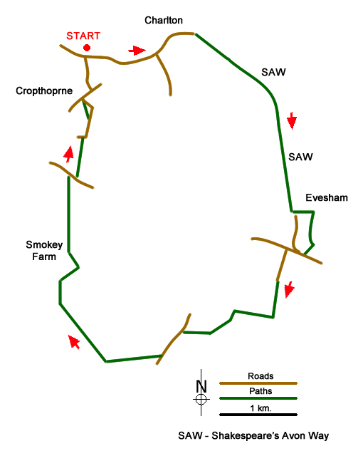
This Worcestershire walk starts from the lay-be on the east side of the Jubilee Bridge across the River Avon on the northern edge of the village of Cropthorne (grid ref. SP001456). The route explores the countryside to the south using a section of the Shakespeare's Avon Way to reach the town of Evesham. From here the walk continues using tracks and paths to explore the fruit growing area of the Vale of Evesham.
After parking, exit the parking area and turn left to walk east along the road. Follow the road around to the left at the first junction and continue into the village of Charlton. Continue straight ahead along Ryden Lane where the road bends to the right to cross a stream. Pass a chapel on your left and continue ahead ignoring the road on your right. Ryden Lane is now followed for 3.2 kilometres soon joining the Shakespeare's Avon Way. Pass Ryden Farm on your left, and then Rawling's Farm also on your left. Continue ahead ignoring cross tracks. Ryden Lane ends (grid ref. SP025446) and becomes Red Lane. Continue past a telecoms mast on your left to a waymarked junction (post on your left). Go straight ahead and after 100 metres take the path on the left just before a modern house.
The path crosses a sloping field (keep to right-hand edge) and continue down to a terrace in the slope. The path is blocked shortly after, so you need to go left and then right to find a way through some scrub to re-join the path. Continue ahead and descend to Hampton Ferry (grid ref. SP029436). Turn right along the riverside path. At the next fingerpost turn right and walk up to the B4084. Turn right along the A4084, cross the road as soon convenient and continue past the Cider Mill pub to turn left into Peewit Road. Continue along Peewit Road to join a bridleway (grid ref. SP024427).
After 400 metres the bridleway turns right marked by a post in the grass on your right, which is easily missed. Continue along the left-hand field edge. Continue ahead for 500 metres and turn left. Shortly after the path bears right and crosses Merry Brook via a footbridge to pass through a riding centre to reach Haselor Lane (grid ref. SP012422). Turn left and continue past the entrance to Upper Haselor Farm on your right. After 100 metres locate a stile on the right and follow this path through an orchard to the top of Haselor Hill. Continue ahead down through trees into a field to meet a bridleway. Turn right and aim for the far right-hand corner of the field.
Continue through the gate (grid ref. SP002419) into a field. The route goes diagonally left across the first field, then straight across the next and the diatonically right across the next to another gate (SO997425). Turn right and continue with field boundary on your right to join an enclosed track. The track turns sharp left to reach a bungalow on the left (Smokey Farm?). Continue ahead on to a Smokey Lane. Follow this lane for a kilometre to reach the B4084. Turn right and then left into Field Barn Lane. Follow Field Barn Lane for one kilometre to a T-junction. Turn left into Blacksmiths Lane. Turn right into Main Street and where the road forks, bear left into Neigh Lane which leads you back to the start.
Messaging & Social Media
Message Walking Britain and follow the latest news.

Mountain Weather
Stay safe on the mountains with detailed weather forecasts - for iOS devices or for Android devices.