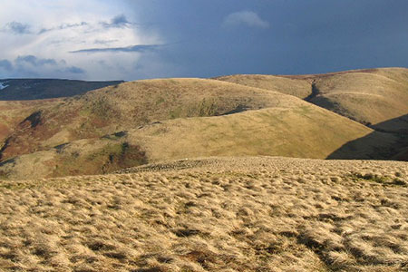
Blackhaggs Rigg & Great Hetha from Hethpool
Northumberland Walk
Nat Park - Northumberland
County/Area - Northumberland County & Scottish Borders
Author - Lou Johnson
Length - 9.6 miles / 15.6 km Ascent - 2100 feet / 636 metres
Time - 6 hours 50 minutes Grade - moderate
Maps 

| Ordnance Survey Explorer OL16 | Sheet Map | 1:25k | BUY |
| Anquet OS Explorer OL16 | Digital Map | 1:25k | BUY |
Walk Route Description
Click image to see photo description.
This Northumberland walk starts from Hethpool and explores the Cheviot Hills west of the College Valley. The route heads upstream, following the College Burn into the hills lying along the England Scotland border. Turning west the walk passes a hill fort on an ascent of Blackhaggs Rigg to reach the border at Black Hag. Turning north the route continues along the border to join the Pennine Way for a short section to reach White Law. Turning east the route crosses the flanks of Madam Law to reach the isolated farm at Trowupburn from where and ascent to the hill fort on Great Hetha. The route sees few walkers and the views are exceptional.
The start is the small parking area at Hethpool (grid ref. NT894281). After parking walk south along the private road into the upper College Valley. Continue for about three kilometres to pass the access drive to Whitehall Farm on your left (grid ref. NT888259). 650 metres beyond the drive turn sharp right at a signpost to Trowupburn (grid ref. NT888254). Follow the Hillfort Trail waymarks which will lead you up to an Iron Age hillfort and a large cairn (grid ref. NT884250) where you can enjoy an extensive view.
Leave the fort and head south west past a sheepfold and then head uphill onto Blackhaggs Rigg. Continue through a small gate in the fence ahead. Turn left and follow the fence onto Black Hag to reach the border fence/wall (grid ref. NT861237). Turn right along the border with the fence on your left. Continue as far as a gate on the left. Climb the gate into Scotland and turn right through another gate. You are now on the Pennine Way.
Enjoy the views as you head north descending the ridge of Steer Rigg before heading uphill to the summit of White Law (grid ref. NT857261). Turn right through the gate into England and follow the fence (on your left) downhill to Wideopen Head. At the broad col, turn right onto a track contouring across the hillside to reach some sheep pens (grid ref. NT871265). From here bear right downhill to pass through a gate at Trowupburn Farm. Continue past the farm (on your right) to join a tarmac lane heading uphill. After 400 metres turn right onto a signed footpath to Great Hetha.
Follow the grassy track uphill with several way markers to assist route finding to reach the hill fort earthworks on top of Great Hetha. The view from the summit is again outstanding. Continue following way markers downhill to reach the left-hand corner of a plantation. Turn right along the edge of the plantation and continue down to the private road used at the start of the walk. Turn left and return to the start.
Other walks nearby
| Walk 2299 | The Cheviot | moderate | 9.0 miles |
| Walk 1201 | Black Hag from Kirk Yetholm | moderate | 8.5 miles |
| Walk 1764 | The Cheviot from Langleeford | mod/hard | 8.2 miles |
| Walk 1765 | Comb Fell & Hedgehope Hill from Langleeford | mod/hard | 8.9 miles |
| Walk 1776 | The Cheviot & Auchope Cairn from Langleeford | mod/hard | 10.0 miles |
| Walk 2152 | Hartshope Linn (waterfall) from Langleeford | easy | 4.4 miles |
| Walk 2153 | Housey Crags from Langleeford | easy/mod | 2.0 miles |
| Walk 2677 | Circuit of Doddington Moor | easy | 3.8 miles |
| Walk 1894 | Burnhope Reservoir Circular | easy | 2.8 miles |
| Walk 3296 | Grubbit Law & Hownam Law from Morebattle | moderate | 7.0 miles |
Recommended Books & eBooks
Hadrian's Wall Path
 Hadrians Wall Path guidebook to walk the 84 mile National Trail. Described in both directions, the main description is west to east between Bowness-on-Solway and Wallsend, Newcastle, with extensions to Maryport and South Shields. With extensive historical information related to this World Heritage site and separate 1:25,000 OS map booklet included.
More information
Walking in Northumberland
 This guidebook contains detailed route descriptions for 36 day walks in Northumberland including the Cheviot Hills. The terrain varies from wild walks and craggy ascents to gentle riverside strolls. Each route ranges from 4 to 16 miles in length and there is the opportunity to link several walks together to create longer treks.
More information
Messaging & Social Media
Message Walking Britain and follow the latest news.

Mountain Weather
Stay safe on the mountains with detailed weather forecasts - for iOS devices or for Android devices.