Walk 3650 - printer friendly version
Rackwick, Old Man of Hoy & Cuilags Walk
Author - Lou Johnson
Length - 9.6 miles / 15.6 km
Ascent - 1650 feet / 500 metres
Grade - mod/hard
Start - OS grid reference ND202993
Lat 58.8736370 + Long -3.3856618
Postcode KW16 3NJ (approx. location only)
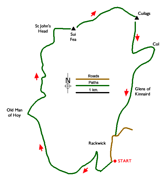
This circular Orkney Islands walk starts from Rackwick on the island of Hoy and follows a well-trodden path to visit see the sea stack of Old Man of Hoy which rises to 449 feet (137 metres) above the sea on the dramatic west coast of the island. The route then continues north along the coast to St. John's Head where the cliffs rises 1000 feet above the sea. Turning inland, the walk crosses the minor top of Sui Fea before climbing to the rocky summit of Cuilags and a descent back to Rackwick.
The walk starts from the free car park (grid ref. ND202993) which lies at the end of the road at Rackwick. After parking, exit the car park and take the second track on the left (past green refuse bins) and continue along the track which later turns sharp right. After 600 metres turn sharp left and join the clear path climbing up the hillside. The path soon gains height, skirts the clifftops, and turns north to arrive at the Old Man of Hoy.
The walk continues north along the coast path with St. John's Head the next objective. The path climbs steadily and after an interesting and spectacular three kilometres you reach St. John's Head where the cliffs are over 1000 feet high. From here the route turns east over pathless terrain. Continue east making the brief climb onto the minor top of Sui Fea with its OS trig point. Continue east initially descending to the left of the lochan just east of the summit. Maintain direction passing to the left of a group of small lochans (grid ref. HY199034) and continue to the top of the crags at Enegars.
From Enegars turn south east and complete the steady climb to the summit of Cuilags (grid ref. HY210034). The summit offers an excellent view across a glen to Ward Hill, the highest summit on the Orkney Islands, and north to the mainland. To start the descent head south from the summit. For about a kilometre to the 300-metre contour. Then turn north-east to cross the steep slope at an angle dropping down to the col (spot height 116 metres). Reaching the col, pick up the main path and turn south to the Glens of Kinnaird. Continue along the path to reach the road (grid ref. HY202000). Turn right and ignoring the road on the right continue to the car park.
Isle of Hoy - there is a car ferry operating from Houton to Lyness on the south-eastern coast of Hoy. Day trips are possible although it is worth checking the timetable before deciding your plan. A passenger ferry also operates from Stromness to Moaness, also on the east coast of Hoy. Reaching Rackwick is possible by pre-booking a taxi. Accommodation and refreshments on Hoy are limited so again careful research is required before making plans. It is probably easier to take a packed lunch and refreshments for this walk.
Messaging & Social Media
Message Walking Britain and follow the latest news.

Mountain Weather
Stay safe on the mountains with detailed weather forecasts - for iOS devices or for Android devices.