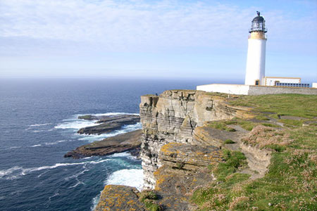
Noup Head from Backarass Farm, Westray
Orkney Islands Walk
County/Area - Orkney Islands - Isle of Westray (Orkney)
Author - Lou Johnson
Length - 4.5 miles / 7.3 km Ascent - 700 feet / 212 metres
Time - 3 hours 0 minutes Grade - easy
Maps 

| Ordnance Survey Explorer 464 | Sheet Map | 1:25k | BUY |
| Anquet OS Explorer 464 | Digital Map | 1:25k | BUY |
Walk Route Description
Click image to see photo description.
This walk from Backarass Farm explores the Noup Headland on the northernmost tip if the Island of Westray in Orkney. The route follows grassy cliff top paths to the lighthouse before joining a track back to the start. The walk offers stunning coastal scenery including caves and rock arches in a remote location. In addition, abundant bird life can be seen in season as part of the route enters the renowned Noup Cliffs Nature Reserve.
Backarass Farm (grid ref. HY412482) lies about 2 miles (3 Km.) west of Perowall along a quiet rural lane. After parking take the path south down to the coast. Turn right and follow the grassy path with the sea to your left. Almost immediately you can enjoy the many interesting coastal features passing a rock arch soon after joining the coast path. The onward route passes above a cave before crossing the flank of North Hill to enter the Noup Cliffs Nature Reserve.
Allow plenty of time to absorb the many rock features and, in season, the extensive bird life. Further caves and rock arches are passed before a short ascent takes you onto Deil Place with its OS trig column. This small area of high ground offers a good view north to the lighthouse and Noup Head. Continue to the lighthouse (grid ref. HY392499). If you have time continue ahead to explore Noup Head.
To return to the start, take the track from the lighthouse heading east. The track provides easy walking with views down to the coast on your left. Continue past Noup Farm on your left, which occupies a lonely location in the lee of North Hill protecting it from the prevailing westerly wind. Follow the lane as it bends sharp right for a gentle ascent across the side of Couters Hill back to the start.
Isle of Westray - there is a car ferry operating from Kirkwall to Sulland on the south coast of Westray. Day trips are possible although it is worth checking the timetable before deciding your plan as the service is not daily. Accommodation and refreshments on Westray are limited so careful research is required before making your plans. Taking a packed lunch and refreshments is recommended for this walk.
Other walks nearby
| Walk 3742 | Westness Heritage Trail | easy | 3.0 miles |
| Walk 1991 | Vat of Kirkbuster & Bay of Houseby | easy/mod | 7.6 miles |
| Walk 3652 | The Gloup, Deerness Brough & Mull Head | easy | 4.0 miles |
| Walk 3648 | Old Man of Hoy & Glens of Broadiface | moderate | 10.0 miles |
| Walk 3649 | Old Man of Hoy from Rackwick | easy/mod | 5.4 miles |
| Walk 3650 | Rackwick, Old Man of Hoy & Cuilags | mod/hard | 9.6 miles |
| Walk 1666 | Stacks of Duncansby | easy | 3.0 miles |
| Walk 3287 | Morven, Smean & Maiden Pap | hard | 10.2 miles |
| Walk 2530 | The Foinaven & Arkle Traverse | very hard | 16.5 miles |
| Walk 1318 | Sandwood Bay | moderate | 10.0 miles |
Recommended Books & eBooks
No suggestions for this area.Messaging & Social Media
Message Walking Britain and follow the latest news.

Mountain Weather
Stay safe on the mountains with detailed weather forecasts - for iOS devices or for Android devices.