Nash Head, St. Donat's & Marcross
Vale of Glamorgan Walk
County/Area - Vale of Glamorgan
Author - Lou Johnson
Length - 5.0 miles / 8.1 km Ascent - 400 feet / 121 metres
Time - 2 hours 50 minutes Grade - easy
Maps 

| Ordnance Survey Explorer 151 | Sheet Map | 1:25k | BUY |
| Anquet OS Explorer 151 | Digital Map | 1:25k | BUY |
Walk Route Description
Click image to see photo description.
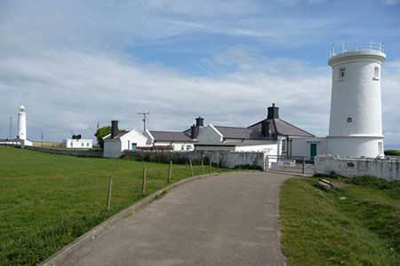
The circular walk in the Vale of Glamorgan passes the twin Nash Point lighthouses to follow a section of the coastal footpath with views across the Bristol Channel to Exmoor. The cliffs on this section show the ravages of the sea on the strata. The route turns inland through the estate of St. Donat's Castle before crossing pleasant countryside to Marcross. The final section of the walk follows Cwm Marcoes back to the start.
The start is the Nash Point car park located a few miles south of Marcross (grid ref. SS916683). After parking follow the coastal path which is part of the Valeways Millennium Heritage Trail (VMHT). Continue past the two lighthouses and continue along the clifftop path for 1.5 kilometres to St. Donat's Bay. The path continues through a short section of woodland, follows the clifftops, and then re-enters woodland. Exiting this wood, you reach St. George's Field at a kissing gate (grid ref. SS940679).
Turn left following the waymarked VMHT to reach a road after 300 metres. Turn left along the road following the VMHT. Follow the main road as it bends to the right. Continue for about 300 metres and turn sharp left into the grounds of St. Donat's Castle (waymark on left-hand gatepost). Reaching an arched gateway, bear half right and follow the lane to reach St. Donat's Church on your left (grid ref. SS934681). Bear right and follow the path up through trees to Parc Farm.
Pass through the farm and take the left-hand fork. In a few metres turn left to continue along the VMHT through a gate with an adjacent stile (grid ref. SS932685). The path initially follows the hedge before heading half right across a field. The path leads onto a track at Marcross Farm. Turn right and pass the farm on your left. The track leads through a gate onto a lane (grid ref. SS928687). Follow the lane to reach a road.
At the road junction, go slightly left and cross a stile onto a path heading north. The path crosses fields to reach another lane near Lan Farm. Cross the road and take the stile opposite. The path goes half left across a field to a track at Pen-y-Cae farm. Turn left to the road. Bear left along the road and in a few metres turn right over a stile in the hedge (grid ref. SS924695). Initially follow the right-hand hedge. The path passes through the hedge and then continues along the left-hand side of another field to pass behind a house. Maintain direction into another field and continue to the end of this field. The path turns sharp right down to a stream. Cross the stream and turn sharp left and follow the path to a road. Turn right along the road and return to the start.
Other walks nearby
| Walk 1884 | Dunraven Bay & Ogmore-by-Sea | easy/mod | 6.6 miles |
| Walk 1221 | Selworthy Beacon & North Hill from Bossington | moderate | 8.5 miles |
| Walk 3725 | Selworthy Beacon from Selworthy | easy/mod | 5.5 miles |
| Walk 2211 | Minehead to Dunster | easy | 5.0 miles |
| Walk 1262 | Watersmeet & Foreland Point | mod/hard | 10.5 miles |
| Walk 1263 | The Doone Valley | moderate | 8.5 miles |
| Walk 3729 | Foreland Point | moderate | 5.0 miles |
| Walk 1910 | Countisbury and Watersmeet from Lynmouth | easy/mod | 4.5 miles |
| Walk 3391 | Valley of Rocks frrom Lynton | easy/mod | 3.8 miles |
| Walk 1750 | Dunkery Beacon (short ascent) | easy/mod | 2.5 miles |
Recommended Books & eBooks
No suggestions for this area.Messaging & Social Media
Message Walking Britain and follow the latest news.

Mountain Weather
Stay safe on the mountains with detailed weather forecasts - for iOS devices or for Android devices.